Another DEATH in BASANTIPUR
Indian Holocaust My father`s Life and time - Fifty Three
Palash Biswas
Dineshpur
From Wikipedia, the free encyclopedia
Jump to: navigation, search
Dineshpur
Coordinates: (find coordinates)
Time zone: IST (UTC+5:30)
Country India
State Uttarakhand
District(s) Udham Singh Nagar
Population 8,856 (2001[update])
Dineshpur is a town and a nagar panchayat in Udham Singh Nagar district in the state of Uttarakhand, India.
[edit] Demographics
As of 2001[update] India census[1], Dineshpur had a population of 8856. Males constitute 52% of the population and females 48%. Dineshpur has an average literacy rate of 57%, lower than the national average of 59.5%: male literacy is 55% and, female literacy is 42%. In Dineshpur, 17% of the population is under 6 years of age. it has only one English medium school best school of the locality named as "New Era Public School"
http://en.wikipedia.org/wiki/Dineshpur
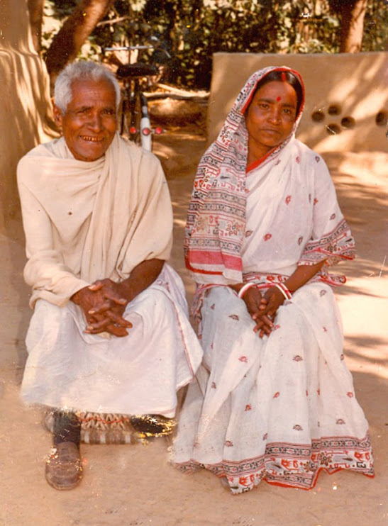
My youngest brother PANCHANAN whom we call Panchoo, called me this morning and informed that my friend KRISHANA, Krishna Pad Mandal died last night at 3AM. He was trying again and again but could not connect me earlier. My son Tussu alias STEVE has an EXTENDED Friend circle and thanks to them my land phone remains all time busy. More over, I had to opt for DATAPHONE dial up for internet connection due to DOWNLOAD BILLING unbearable! I have a CELL PHONE. In fact, I avoid mobile phone due to unnecessary engagement all the time. It remains with my wife. REDS friends based in Bangalore, gifted me a CELL Phone last year to get me connected. But I got the set BURNT by overcharging. Since then , a friend engaged in repairing mobile phones gave me an old NOKIA SET. But the Batterry betrays now and then like my Mraxist frinds boasting commitment and ideology! I have to visit Maharashtra since next 26 january. Friends based in Maharashtra are finalising my schedule there. But connectivity remains a great problem for me nowadays despite a telephone bill amounting about Rs Five Thousand this time.
I got the news very late. had I recieved the news earlier, perhaps it would not make any difference. Just because of distance, Time and Money Crunch I could not manage to revisit my native Village BASANTIPUR since my mother BASANTI DEVI died in June, 2006. I am IMPULSIVE and quite a HEADSTRONG person as my friends complain. May be I am. But it happened like this thta while i left my home in Basantipur, I, for the first time in my life, bowed before the TULSI BIRWA denoting HOME GODDESS! The FEELING was overwhelming as I felt afraid that may be, I would not be able to return. All elders in the family expired. My mother was the last one. it had to be my number next time, I thought. But it was the number for my nephew, the eldest son of my cosin sister MEERADI, SHEKHAR. but I could not visit home. Meanwhile I visited Patna, new delhi, Bhuvneshwar and many places in West Bengal. But it never happened to be BASANTIPUR.
In 1990, my nephew, just six year old BIPLAB died while I was in Bareilly. he expired in the night and we reached home by afternoon. The death made me DETACHED. Since then, I was never afraid of DEATH. All elders passed away one by one, I did not weep.
Today, it was very hard for me once again as i had to struggle to stop tears!
My heart is exposed so wildly. My wife went Open Heart surgery in June, 1995. She was operated by DR Devi Shetty in BM Birla heart research centre, kolkata. Savita`s RIBs were cut through for the open heart surgery. Even after the time of years spent after the Open heart surgey she has to cry with PAIN. I feel PAINED in such a fashion leaving my VILLGE long before driven by sheer ambition to be recognised. I am not a little bit recognised as yet. But i have been disassociated with my family, home, Village and childhood for ever.
But my Childhood haunts me like BROKEN RIBs of my ailing wife! She is under medical supervision for which I have to earn a minimum amount every month despite my anarchist life style! I am not MAXIM GORKY or LEON URIS as I could be able to place my HEART in Mcroscope in PRINT. We lived the GHETTO life and brought up as all black Untouchables are born and brought up!
I have written it so many times that BASANTIPUR happens to be an Extended family set up by my late father and his comrades who got their last shelter in nainital Terai after roaming in West Bengal and Orisssa being ejected out of Home land in east Bengal due to Partition haolocaust. Only two persons Gyanendra Mandal and Ganesh Mandal above eighty years, two persons crossin seventies KARTIK SANA and BIDHU ADHIKARI and three persons crossing sixty five Hari Mohan biswas, Pulin Gaine and Shishubar Mandal survived while I visited my village last time who suffered the pangs and plights of partition.
A full generation between 55 to 65 is wiped out slowly and consistantly.
KRISHNA aged Fifty Five was senior most amongst us.
As the LEGEND realted to Nainital Terai goes on , it is believed that the Terai belt had been INHIBITED seven times and had been destroyed SEVEN TIMES. Present population happens to be the eighth one. The region came into lime light by no one else but a personality like GIM CORBETT famous for his writings like Man eaters of Kumaun! Corbett encountered the man eaters as well as the legendary Daku of Terai region SULTANA DAKU! But a dare devil person like CORBETT also avoided to tread RUDRAPUR PANTNAGAR DINESHPUR GULARBHOJ region as it was CURSED with FLOODS, PLAUGE and MALARIA! Thoght the RAILWAY Network connected Gularbhoj with Kashipur Lalkuan meter gauge line in BRITISH period for TIMBER BUSINESS! Rest of the zone had been untouched. As the chief minister of UTTAR PRADESH, Pdt Govind Ballabh Pant failed to convince the Hill people to inhibit terai. The Desi Kings, Nawabs, Princes, OFFICERS, Service Men and Indian capitalist of the colony used the REGION as HUNTING GROUND. They used to camp here and there for Hunting Purpose only. the Mughals and Pathans were afraid of the region. Riast RAMPUR had most of the property in the area near BILASHPUR and GADARPUR but they could not manage it. In accordance with the Legend RUDRAPUR, the present head quarter of UDHAM SINGH NAGAR District was the CAPITAL of KING RUDRA. He lost his way in the JUNGLE and DEVI ATARIA appered. So we had to participate in ATARIA MELA. Now the venue has become the DISTRICT HEAD QUARTER! Kashipur remained the place governed BY Devi Chaiti. But either of the goddesses could not prevent PLAGUE and MALARIA in Terai. TYher had been a KHAM SUPERINTENDENT who was responsible to see the FOREST LAND. He could allot land to anyone. The KHAM Bandobast remained till 1952. IAS, IPS officers, MILITARY Officers, Kings and Princes, Nawabs, Political leaders like Prakash Ningh Badal, Pratap singh Kainro, Surajeet singh Barnala, CB GUPTA, HEMBATI NANDAN Bahuguna, ND TIWARI, Styendra Guria, Rajmangal Tiwari, Industrialists, business houses, Film stras like Dharmendra and Shashikala got farming land in Terai. The KHAM SUPER alloted thosands acres of land on any paper available even on cigarrette packet at the rate of RS ONE only. PRAG Farm had 72 thusands acres of land only. ther had been no ceiling. But the cultivation deep on the forest was impossible due to the absence of labour force. Tharu and BUKDSHA tribals inhabited the Jungles only. they knew only JHOOM cultivation.
According to Historians, hundreds of years ago village Rudrapur was established by a devotee of lord Rudra or by Hindu tribal chief called Rudra, which has passed through phases of development to take the shape of city Rudrapur. The importance of Rudrapur has increased as it is the head quarter of district Udham Singh Nagar. During the reigns of mughal emperor Akbar this land was handed over to king Rudra Chandra in 1588. The king established a permanent millitary camp to free tarai from day today invasions. Totaly neglected village Rudrapur was filled with new colours and human activities.There is a saying that Rudrapur was named after king Rudra ChandraDuring the reigns of Britishers, Nainital was made a district and in 1864-65 the whole Tarai and Bhawar was put under "Tarai and Bhawar Government Act" which was governed directly by the British crown.
The history of development started with 1948, when the problem of partition brought refugee problem with it. Immigrant from north west and eastern areas were reestablished in 164.2 square km land area under "up nivesh yojana". Personal dwellers were not alllotted land in accordance with crown grant act. The first batch of immigrants came in December 1948.
People from Kashmir,Punjab,Kerala,Eastern UP,Garhwal, Kumaion,Bengal, Hariyana,Rajasthan, Nepal, and Naidu live in groups in this districts.This country is an example of unity in diversity with people from many religions and professions and so is this Tarai, which has its heart at Rudrapur. Due to this Tarai was named MINI HINDUSTAN.
According to a folktale when king Rudra was passing through, his chariot got stuck into marshy land, so he decided to build a temple and well at that place. The present Atariya temple is the same At a distance of 2 kms. from the bus stand and half a kilometre away from the Rudraur-Haldwani motor route. Every year during the occasion of 'Navratras' a large fair is held here and thousands of devotees come to seek the blessing of Goddess Atariya. The fair is held for 10 days.
In 1922, no less than FORTY BUKSHA Villages in between bilashpur and gadarpur perished suffereing PLAGUE! The panic was so great that the GURKHAS ruling Kumaun and garwal never tried any adventure in the TERAI. DEFEATING the Gurkhas, the BRITISH EMPIRE failed to colonise the Jungle of Terai. hence the KHAM Bandobast was INTRODUCED to make INHIBTION possible.
In 1952, Kham bandobasta was cancelled. meanwhile the Government of India had to encounter the problem to rehabiliate the REFUGEES from East Bengal and Punjab, PDT Nehru was POSING as Socialist and had adopted SOVIOT DEVELPOPMENT Pattern. He planned to rehabiliate the East bengal and Punjabi partition victim refugees along with FREEDOM Fighters in the Terai in a COMMUNE PATTERN in which land Settlement societies had to be leased land for 99 years.
Basantipur was also a land settlement society! Which came up along with UDAINAGAR and panchananpur after REFUGEE MOVEMENT led by may father in 1956 in Rudrapur. The Refugges in agitation had been dumped into deep forest of KELAJKHERA before the REHANBILIATION Plan finalised. Our people were stranded in Vijay nagar camp. rest of 33 bengali colonies were set up during 1952 to 54 along with SIKH and RAI SIKH refugees. Dinshpur was the centre of bengali colonies. In 1960, the UP Government colonised Shaktifarm 36 KM away and sitautae and surrounded by Jungle.
In our childhood, we enjoyed the WILD LIFE very musch and had been habitual to live with Tigers, Elephants, Bears, Deer, Hares, Foxes and so many species of BIRDS. All the rivers and rivulets flowing from the Hills were UNBOUND.
Luckily, Plague did not return in TERAI next time. So terai SURVIVED this time but it was STRUCK by Land and political Mafia against which DHEEMRI BLOCK Peasants` UPRISING took place and once again my father was the leader.
But our people suffered from Malaria, Dysentry, Influenza, Gastric Alsur and so on. Child death was daily affair and we had not to weep for dead children or Older people! So many children in our own family expired in early months that we could not remember!
We got DEEP TUBE Well water only after 1967. Meanwhile GASTRIC Ulsur appeared like Destiny Reincarnated in DEATH. We had the most popular jatra Party in the Region. Even today, BASANTIPUR Cultuarl team is well known al over UTTARAKHAND. The JATRA party PERISHED only Kartik SANA , the Hero survives as HERO never dies! Phani Dhali, Haju Sana, Haripada Mandal, Pado Gaine, Mahahendra Mandal, all of them popular artists died suffering Gastric Ulser! The generation Next after the ELDERS who would have consist 55 to 65 age group was CURSED with Terai Epidemics and Persished.
I may not remeber a single INSTANCE while Krishna and ME had any difference on any issue. He lost his father in 1975 while he was a student of class eleven perhaps. he belonged to Paundra KSHATRIYA caste. Most of Basantipur residents belonged to this caste barring a few being Namashudra, malo, Mahishya and kayashtha. We had two Brahmin families for supervising our rituals, The chakrabarties and the Chatterjees!
Krishna`s father was a tall, healthy man and he was the President of the land settlement society. He was responsible for our defence and all internal affairs. Shishubar Mandal was a literate man and he was the cashier who kept accounts of the Village. Atul Sheel, by caste a BARBER, was the secretary. He died after my father in 2002. I had a miracle amongst the VILLAGE Children. As I had some or other WAVELENGTH to connect with all the ELDER People in the villages. Wheteher they would differ in Opinion , they would never reject my suggestion. Mandar Babu and his wife loved me most. Though KRISHNA was two orthree years older then me, Mandar Babu on Death Bed told me to care for KRISHNA.
krishan was our Captain. In the Village as well as in the SCHOOL. He was expert in every game. he had been a Marvellous ATHELETE. We made him our CLUB President. I was the Secretary. We never had nay diference. in fact, Basantipur People as well as the Children had no difference at any point of time. We had to struggle all the time and we knew well that we would not be able to sustain ourselves if divide. We were afraid of PARTITION anymore. hence, the Bengalies always accepted PULIN Babu, my father as CONSENSUS unopposed leader in nainital district as well as all over in UTTAR PRADESH.
People from Barishal and Khulna districts were traditionally habitual of CHILD MARRIAGE. Specially the Paundra Kshatriyas. krishna got married in 1973 while he was a student of class Nine and I just appeared in Highschool exams. She was the sister of one of our Schoolfriend JAMINI from Makarandpur. The girl was beautiful and elegant. They got a BOY cllaed Pardeep and a Girl, I always confuse the name as Krishan`s sister Arati was so dear to all of us. I always nake the mistake to call the daughter as AARATI!
While I was in Dhanbad, we got the news just after Savita settled with me, Krishan`s wife expired! Krishna was just in twenties but he never did think of Remarriage despite Pressure from friends, kith and kin. Pardip got married while I was well settled in Kolkata. But the Daughter was studying in College in rudrapur and all of us were worried to get her married.
Everytime I visited Basantipur, the FATHER and the DAUGHTER would recive me in front of their home. They would spend all the time on the cot. Whenevr I left the Village , they would say me good bye.
Krishna proved to be a popular leader and had been elected as Panchayat Pradhan for long time. He was also popular amongst the Sikhs. I would meet all the Sikhs at his home everytime. The seta has been reserved for woman now. Krishna never tried to hold on power as he could opt for woman candiate from his family. the daughter was quite elgible. He has Five Brothers and so many cousins. But he supported a vilage woman, the wife of Kangal. kangal is very junior to us.
Last Winter only, Krishna called me and informed that the daughter has to get married and I have to reach Home. I could not. the daughter got married last year and lost her father and our Friend this year!
Udham Singh Nagar was a portion of district Nainital before the Tarai belt was separated to form the present Udham Singh Nagar on 30/09/1995. In the past this land which is full of forest land was neglected till 1948 due to difficult climate. Marshy lands, extreme heat, rains which lasted months,a place full of wild animals, diseases and no means of transportation prevented the human race to form a colony here.
According to Historians, hundreds of years ago village Rudrapur was established by a devotee of lord Rudra or by Hindu tribal chief called Rudra, which has passed through phases of development to take the shape of city Rudrapur. The importance of Rudrapur has increased as it is the head quarter of district Udham Singh Nagar. During the reigns of mughal emperor Akbar this land was handed over to king Rudra Chandra in 1588. The king established a permanent millitary camp to free tarai from day today invasions. Totaly neglected village Rudrapur was filled with new colours and human activities.There is a saying that Rudrapur was named after king Rudra Chandra.
During the reigns of Britishers, Nainital was made a district and in 1864-65 the whole Tarai and Bhawar was put under "Tarai and Bhawar Government Act" which was governed directly by the British crown.
The history of development started with 1948, when the problem of partition brought refugee problem with it. Immigrant from north west and eastern areas were reestablished in 164.2 square km land area under "up nivesh yojana". Personal dwellers were not alllotted land in accordance with crown grant act. The first batch of immigrants came in December 1948.
People from Kashmir,Punjab,Kerala,Eastern UP,Garhwal, Kumaion,Bengal, Hariyana,Rajasthan, Nepal, and Naidu live in groups in this districts.This country is an example of unity in diversity with people from many religions and professions and so is this Tarai, which has its heart at Rudrapur. Due to this Tarai was named MINI HINDUSTAN.
GEOGRAPHY
The district is situated at 28 degree south east, 30 degree north latitude, 78 degree and 81 degree east longitude of Kumaion. Nainital is to the north, Bijnour, Moradabad,Rampur to west,Bareilly, Pilibhit to south and district Champawat is in the east of this district. South east lies the border of Nepal. Reserved forest area lies at the borders of district Nainital and Champawat. The total district is Tarai. Water is available at the depth of 10 to 20 meters. Due to its special geographical structure the district is leader in agriculture in the country. The district is situated at 28 degree south east, 30 degree north latitude, 78 degree and 81 degree east longitude of Kumaon. Nainital is to the north, Bijnour, Moradabad, Rampur to west, Bareilly, Pilibhit to south and district Champawat is in the east of this district. South east lies the border of Nepal. Reserved forest area lies at the borders of district Nainital and Champawat. The total district is Tarai. Water is available at the depth of 10 to 20 meters. Due to its special geographical structure the district is leader in agriculture in the country. The area of the district is 3055 square km. It is divided into three parganas, 4 tehsils,2 sub tehsils. There are 669 revenue villages and 15 forest villages. Out of 669 villages 298 villages are in tehsils Kashipur, 159 in tehsil Kichha, 122 villages are in tehsil Sitarganj and 90 in tehsil Khatima. There are 7 blocks for development work. They are Jaspur, Kashipur, Bajpur, Gadarpur, Rudrapur, Sitarganj and Khatima. These 7 blocks are further divided into 27 Nyaya Panchayat and 326 village Panchayat. Urban area is divided into 8 Palika Parishad Jaspur, Kashipur, Bajpur, Gadarpur,. Rudrapur, Kichha, Sitarganj and Khatima and 7 Nagar Panchayat MahuaDabra, Mahuakheraganj, Kelakhera, Dineshpur, Sultanpur Patti and ShaktiGarh. POPULATION AND DENSITY ,CENSUS:- According to 1991 census population of Udham singh Nagar is 9.15 Lakhs In which 4.91 Lakhs are Male and 4.24 lakhs are Female. Schedule caste population is 1.21 lakhs and schedule tribe population is .86 lakhs.According to 1991 census total area of Udham Singh Nagar is 1.12 percent of U.P and .65 percent people of the total of U.P. reside here. Population density of U.P is 473 per square kilometer and population density of this district is 299 per square kilometer. In comparison with Uttaranchal 5.75 percent area is of Udham Singh Nagar. Population density of uttaranchal is 132 per square kilometer and this district has 299 per sqaure kilometer. 9.8 percent schedule caste and 40.7 % schedule tribe of Uttaranchal reside in Udham Singh Nagar. According to the census of 1991, 39.3 percent are literate. In literate persons 66.7 % are male and 33.3 % are female. According to the census of the 1991 the number of residential houses in the district is 148497 in which 100089 are in rural area and 48408 are in urban area. According to the 1991 census 153484 families live here . 102444 families are in rural area and 51040 are in urban area.
Area
1989 Acre
Population
61,280 (only town as per 1991 census)
Altitude
550 Mtr
Language
Hindi,Pahari,Punjabi
Clothing
Light Cotton,Wollen
STD Code
05944
Season
Round the year
Pin Code
263153
Blocks
Places Of Worship:
Nanak Matta Gurudwara, Panch Mandir, Shiva Temple
Atariya Devi Mandir,Chaiti Mandir Kashipur
Government Accomodation
Irrigation Deptt. Inspection House
Forest Rest House
P.W.D Inspection House
Jaspur,Kashipur,Bajpur,Gadarpur,Rudrapur,Sitarganj,Khatima
Transport
Air: Nearest Airport- PantNagar, 11 Km
Rail: Udham Singh Nagar(Rudrapur) is well connected to Delhi, Lucknow and Calcutta by broad guage line having 14 railway stations in total.
Road: Udham Singh Nagar (Rudrapur) is well connected to important towns and cities country and nearby area having 144 bus stations/halts.
Major Towns of Udham Singh Nagar District
Kashipur
Rudrapur .....................Dineshpur
Khatima ................................Shaktigarh
Sitarganj ............................................Kelakhera
Kichha ..............................Sultanpur Patti
Gadarpur ................Mahua Kheraganj
Bazpur..................Mahuadabra
Jaspur
Palash Biswas. President Bush is the Most Dangerous Man in this World Who Invents .... House Hostel. he was associated with the Naxalite group in Terai led ...
groups.google.co.th/group/topics/msg/f75302b2c68cc164 - 138k - Cached - Similar pages -
Badrinath | Kedarnath | Gangotri | Yamunotri
Uttarakhand home | index | sitemap | bookstore
Udham Singh Nagar District
Udham Singh Nagar was a portion of district Nainital before the Tarai belt was separated to form the present Udham Singh Nagar on 30/09/1995. The district was named in the memory of Late Shri Udham Singh who was a great freedom fighter and who killed General Dyre after the brutal Jaliyanwala Bagh massacre. The district comprises of three main sub divisions Rudrapur, Kashipur and Khatima and is surrounded by the exotic Himalaya ranges.The tehsils in the district are Kashipur, Kichha, Khatima,Sitarganj. Bajpur and Garadpur are sub-tehsils.
Places of Interest include: Atariya, Kanshipur, Chaiti Devi, Nanak Mata and Giri Sarovar
The district is situated at 28 degree south east, 30 degree north latitude, 78 degree and 81 degree east longitude of Kumaon. Nainital is to the north, Bijnour, Moradabad, Rampur to west, Bareilly, Pilibhit to south and district Champawat is in the east of this district. South east lies the border of Nepal. Reserved forest area lies at the borders of district Nainital and Champawat. The total district is Terai. Water is available at the depth of 10 to 20 meters. Due to its special geographical structure the district is leader in agriculture in the country.
In the past this land which is full of forest land was neglected till 1948 due to difficult climate. Marshy lands, extreme heat, rains which lasted months,a place full of wild animals, diseases and no means of transportation prevented the human race to form a colony here. According to Historians, hundreds of years ago village Rudrapur was established by a devotee of lord Rudra or by Hindu tribal chief called Rudra, which has passed through phases of development to take the shape of city Rudrapur.
The importance of Rudrapur has increased as it is the head quarter of district Udham Singh Nagar. During the reigns of mughal emperor Akbar this land was handed over to king Rudra Chandra in 1588. The king established a permanent millitary camp to free tarai from day today invasions. Totaly neglected village Rudrapur was filled with new colours and human activities.There is a saying that Rudrapur was named after king Rudra Chandra. During the reigns of British, Nainital was made a district and in 1864-65 the whole Terai and Bhawar was put under "Tarai and Bhawar Government Act" which was governed directly by the British crown.The history of development started with 1948, when the problem of partition brought refugee problem with it. Immigrants from north west and eastern areas were re-established in 164.2 square km land area under "up nivesh yojana". Personal dwellers were not alllotted land in accordance with crown grant act. The first batch of immigrants came in December 1948. People from Kashmir, Punjab, Kerala, Eastern UP, Garhwal, Kumaon, Bengal, Hariyana, Rajasthan, Nepal, and Naidu live in groups in this districts. This country is an example of unity in diversity with people from many religions and professions and so is this Tarai, which has its heart at Rudrapur. Due to this Tarai was named mini Hindustan.
Ghanta Ghar, Pantnagar University
The area of the district is 3055 square km. It is divided into three parganas, 4 tehsils,2 sub tehsils. There are 669 revenue villages and 15 forest villages. Out of 669 villages 298 villages are in tehsils Kashipur, 159 in tehsil Kichha, 122 villages are in tehsil Sitarganj and 90 in tehsil Khatima. There are 7 blocks for development work. They are Jaspur, Kashipur, Bajpur, Gadarpur, Rudrapur, Sitarganj and Khatima. These 7 blocks are further divided into 27 Nyaya Panchayat and 326 village Panchayat. Urban area is divided into 8 Palika Parishad Jaspur, Kashipur, Bajpur, Gadarpur,. Rudrapur, Kichha, Sitarganj and Khatima and 7 Nagar Panchayat MahuaDabra, Mahuakheraganj, Kelakhera, Dineshpur, Sultanpur Patti and ShaktiGarh.
Population
According to 1991 census population of Udham singh Nagar is 9.15 Lakhs In which 4.91 Lakhs are Male and 4.24 lakhs are Female. Schedule caste population is 1.21 lakhs and schedule tribe population is .86 lakhs.According to 1991 census total area of Udham Singh Nagar is 1.12 percent of U.P and .65 percent people of the total of U.P. reside here. Population density of U.P is 473 per square kilometer and population density of this district is 299 per square kilometer. In comparison with Uttarakhand 5.75 percent area is of Udham Singh Nagar. Population density of Uttarakhand is 132 per square kilometer and this district has 299 per sqaure kilometer. 9.8 percent schedule caste and 40.7 % schedule tribe of Uttarakhand reside in Udham Singh Nagar. According to the census of 1991, 39.3 percent are literate. In literate persons 66.7 % are male and 33.3 % are female. According to the census of the 1991 the number of residential houses in the district is 148497 in which 100089 are in rural area and 48408 are in urban area. According to the 1991 census 153484 families live here . 102444 families are in rural area and 51040 are in urban area.
Year Registered Vehicles
Total RevenueEarned
Light Light Two Wheeler
1997-98 116 1154 3753 5023 40.00 lakh
1998-99 75 1373 4137 5585 121.98 lakh
1999-00 100 1408 4501 6009 224.57 lakh
*According to transport department.
According to statistics of 31-3-2000 there are 27 sub post offices, 78 branch post offices where national saving schemes is also offered. Public is allowed to invest in small investing tools.
On 31/3/2000 there are 247 PCO and 29548 telephone connection in the district. A main post office is also required . The NIC district centre is fully established at collectorate and is running full fledged with all its facilities functioning.
In a democracy government is providing social services in the form of education, medical, health services, water supply etc.
Education: Social reengineering and scientific attitude development is being carried out by the government by providing formal and informal education and carrying out total literacy campaign. On 31/3/2000 915 junior basic schools are there in the district and 229 senior basic schools are also there. 96 middle colleges and 4 government degree colleges are there in Khatima, Rudrapur, Bajpur, Kashipur. 3 private degree colleges are there in NanakMatta, Kichha, Kashipur. 2 polytechnic and 7 ITI , 3 Ashram Padhati Vidyalaya are there. G.B. Pant University of agriculture and Technology imparts technical education. It offers degree courses in civil, agriculture, electrical, mechanical, electronics and computer engineering.
Total Literacy Campaign: This district is selected under total literacy program. 5660 teachers on swayam sevi basis and 559 master trainees help them. A committee under the chairmanship of District Magistrate is there for this purpose. Similar committees are there at the village and lower level.According to health services 1982, the health policy for year 2000 is conceptualized. In 1999- 2000 primary health centers, community health centers and sub centers are 28. In medical services 25 allopathic, 13 Ayurvedic, 2 homeo hospitals, 7 family and mother- child centers. In 98-99 3586 and in 99-00 ,3171 operations were carried out under population control program. In 1998-99, 30.78 thousand children were given polio, 20.78 thousand were given DPD, 29.27 were given BCG vaccines.
1999-2000 has these statistics as 31.87 thousand, 31.86 thousand, In the 9-th five year plan uptil 31-3-2000, 650 villages and 15 urban cities Jal Naigam has offered drinking water. In the district world bank sponsored swajal pariyojana is going on. All the villages have drinking water according to village wise basic statistics.
Industry contributes to give rise to economical development. There is abundance of industry in this land. On 31-3-2000 there are fifty medium sized/large industry in the district. In which 1040.83 crore is invested. 10797 persons are employed in this industry. There are 6 sugar mills, 2 cloth mills,8 paper mills, 2 flour mills, 3 polyster film and chips units. There are 2927 small and medium sized registered units in the district where capital investment is 58.67 lakh rupees employing 1389 persons. 225 rice mills, 5 solvent plants, 11 flour mills,20 processing units, 3 cement producing units and 85 agriculture related instruments are included in it. Apart from this copy making, wooden furniture marble tiles, tyres, printing press, aluminums industry, chips development, stone rolling mills, PVC pipe development units, mentha oil, pharmaceuticals, dal mills etc. are also there.
Main industrial exporting units are M/s Honda seal power products ltd. which produces generator sets, engine water pumping set ,spare parts. M/s ANCO ltd. Rudrapur produce door sealing. M/s Polyplex corporation ltd. Lohia road khatima and M/s Easter industries ltd. P.O Charubeta khatima produce polyster films and chips, polyster paints/PVI chips. M/s Carewell Mandi products ltd. Khatima produce syringes and need les.All the villages are electrified in this district.
There are 18 33/11 KVA stations. One sub-station of 66/11 KVA is in PantNagar.Electricity is generated at Sharda sagar dam situated at Khatima and Banbasa borderPopulation 61,280 (only town as per 1991 census) Altitude 550 MtrSTD Code 05944
Agriculture
The prosperous district is endowed with a very fertile land. Agriculture is the mainstay and there are several agriculture related activities and industries located here. Udham Singh Nagar district is also noted for communal harmony and brotherhood. The district is a melting pot of different cultures, religions and life styles. Rudrapur is the headquarter of the Udham Singh Nagar district.
is a major activity in the district. Leaving the forest area, the remaining 81.2% area is for agriculture.According to revenue department 1997-98 statistics the land utilized is 278775 , 33.4% is in forest, 8.7 % is under agriculture and other use. The district is a leader in agriculture . In this area a through knowledge of seeds, fertilizers , developing agricultural machinery , sufficent means of irrigation and agricultural technology gives rise to very high yield . Govind Ballabh PantUniversity of agriculture and Technology , Pradash Tarai Beej Vikas Nigam have given multifold benefits to farmers . According to 1997-98 Statistics total production of food grains was 517490 Metric Ton, 39.3 % of which was wheat and 59.8% was rice. In the district sugar cane area is 40703 Hectare which gives a production of 25913 Quintal cane. The average produce of sugarcane is 623.52 Quintal per Hectare. Major crops of this land are potato , Dal, Soyabean , Gram, Maze etc. The farmers are given information on agriculture by Project officer Agriculture and by Krishna.htmlishi Raksha AdhiKrishna.htmli . A soil testing lab is situated in the district. For producing Base Seeds to farms of agricultural department are their in the district .
To develop investment in agriculture, district plan has following plans 1.To provide state help in blocks ware tribal population is more on seeds having more productitivty
2. Saghan Krishna.htmlishi Evem Bahu Fasali Yojana .
3. Rashtriyan dalahan vikas yojana
4. EkiKrishna.htmlita dhan vikas yojana .
5. Keet Niyantrana yojana .The district has sufficient resources of industrial development related to agriculture . As far as vegetables are concerned main products are potato ,beans , cauliflower , onion , tomato, ladyfinger etc. are produced. and mango, guava are the produce in fruits.In the district horticulture department has three farms in Sitarganj , Rudrapur, and Gadarpur. Sugar Cane development :- In the year 1997-98 40703 Hectare area was under sugarcane and total produce was 2537913 Quintal. Average production is 623.52 Quintal per Hectare. In the district there are six sugar factories in Jaspur, Kashipur, Bazpur, Gadarpur , Kichha , and Sitarganj . These sugar factories consume sugarcane from neighbouring districts Bijnour , Rampur Bareilly and Pilibhit. To help the sugarcane farmers the cane department has six cane committee in Kashipur , Bazpur , Gadapur, Kichha , Pantnagar . A cane committee is there in Nadehi sugar mill .Animal Husbandry :- According to 1993 animal census the district has 370076 total animals . This being Taria region the position of animals is good here. In the district 23 vetenery hospitals and 70 animals health centers. 93 Krishna.htmlitrim Garbdha Kendra / U.P Kendra there.. In the district there is special emphasis on improving the animal jean. Embryo Transplantation technique , there are many poultries and animal vaccination centers .
The position of animals is good in this district and milk development is an important program. This program is managed successfully.milk federation which has been formed in rudrapur on 31-3-2000. There are 300 milk cooperatives in the district.15000 Members are there in the cooperatives. On an average 22500 liters milk is produced per day. There are two milk refrigeration centers in Khatima and Bazpur, where 221 cooperatives send milk. Remaining 79 cooperatives send there milk to Lalkuan cooperative. 13 channels are there for milk storage. In one year the cooperatives distribute 2000 metric ton balanced animal diet.
Fisheries
In the district fisheries have been developed as a business. There are private/gram sabha/revenue owned small fisheries ponds. The Gram sabha/Revenue department gives these ponds to public on a ten year patta. In the year 1999-2000 12.38 lakh fish seeds was developed and 49.29 lakh seed was distributed.
Road transport and communication
In any land, road, transport and communication are the infrastructure for social, eco and industrial development. After independence government is making investment available for developing these resources. After formation of district in 97-98, 203.54 lakhs , in 98-99 203.65 lakhs, and in 99-2000 358 lakhs is invested under district plan for the same. All the villages above the population of 1000 are connected by roads.
In the district national highways are 130.505 Km, State highways are 85.76 km, major district roads are 190.40 km village roads are 9.5 km and roads under Nagar Palika are 25.60 km, giving total of 1239.60 km. The palika road according to statistics of 97-98 is 1198 km. Per lakh road length is 131 km. Cane committee, district panchayat and Rural Development also make roads which makes total road length 1841 km.
Two roads of UP Transport Corporation are there in Rudrapur and Kashipur, one bus depot is being constructed at Nanak Matta, which will start working soon.
General Information
Area : 1989 acre.
Altitude : 550mts.
Population : 61,280 ( Only town area, as per 1991 census)
Season : Round the year.
Clothing : Summer -Light cotton & in Winter - Woollen
Languages : Punjabi, Hindi & English
Accessibility
Air : Nearest Airport - Pant Nagar, 11kms.
Rail : Udham Singh Nagar ( Rudrapur) is well connected to Delhi, Lucknow and Calcutta by direct broad gauge line.
Road : Udham Singh Nagar ( Rudrapur) is well connected to important towns & cities of the country and nearby area.
Distance in Km : Delhi - 254kms, Agra - 301kms., Lucknow - 343kms., Faizabad- 473kms., Ayodhya- 481kms., Gorakhpur - 620kms., Kashipur - 56kms., Tanakpur - 101kms., Hardwar - 228kms. & Dehradun - 285kms.
Accommodation
Hotel Kanchantara, Hotel Sonia, Hotel Suvidha, Hotel Mid, Town Hotel, Prince Hotel, Mansarovar Hotel Era Hotel Mani Palace Hotel Siddhu Palace, Hotel Ambar
Irrigation Deptt. Inspection House
Forest Rest House P.W.D Inspection House
Restaurants
Sonial Hotel Restaurant
Siddhu palace Bar & Restaurant
Banks
State Bank Of India, Tel.: 83440 Bank of Baroda, Tel.: 81445size=2>Allahabad Bank, Tel.: 83384Punjab National Bank, Tel.: 83454
Oriental Bank Bank of Baroda
Allahabad BankPunjab National Bank
Cinema
Shyam Cinema Hall
Sibbal Cinema Hall
Hospital
Government Hospital, Tel.: 83422
Important Tel. No
District Magistrate, Udham Singh Nagar Tel.: 82344 (O), 82345 (RA.D.M (Finance), Udham Singh Nagar Tel.: 82087S.P. Rudrapur, Tel.: 83907 C.O. City Rudrapur, Tel.: 83921Railway station Rudrapur Tel.: 83410
Airport Incharge, Pant Nagar Airport Tel.: 33709/33685
Post Office
Post Office, Rudrapur
Transport
Air: Nearest Airport - Pantnagar, 11 KmRail: Udham Singh Nagar (Rudrapur) is well connected to Delhi, Lucknow and Calcutta by broad guage line having 14 railway stations in total.
Road: Udham Singh Nagar (Rudrapur) is well connected to important towns and cities country and nearby area having 144 bus stations/halts.
Sources
© 2007 4dham.com - Uttarakhand Information Centre
Badrinath - Kedarnath - Gangotri - Yamunotri
4dham.com - Udham Singh Nagar District
Gadarpur
From Wikipedia, the free encyclopedia
Jump to: navigation, search
Gadarpur
Coordinates: (find coordinates)
Time zone: IST (UTC+5:30)
Country India
State Uttarakhand
District(s) Udham Singh Nagar
Population 13,638 (2001[update])
Gadarpur is a city and a municipal board in Udham Singh Nagar district in the state of Uttarakhand, India.
[edit] Demographics
As of 2001[update] India census[1], Gadarpur had a population of 13,638. Males constitute 54% of the population and females 46%. Gadarpur has an average literacy rate of 64%, higher than the national average of 59.5%: male literacy is 69%, and female literacy is 59%. In Gadarpur, 16% of the population is under 6 years of age.
http://en.wikipedia.org/wiki/Gadarpur
Rudrapur
From Wikipedia, the free encyclopedia
Jump to: navigation, search
For a town in Deoria District, Uttar Pradesh, see Rudrapur, Uttar Pradesh.
for the village in Nepal see Rudrapur, Nepal
Rudrapur
Rudrapur
Time zone: IST (UTC+5:30)
Country India
State Uttarakhand
District(s) Udham Singh Nagar
Population 88,720 (2001[update])
Website: usnagar.nic.in/
Coordinates: 28°59'N 79°24'E? / ?28.98, 79.4 Rudrapur is a city and a municipal board in Udham Singh Nagar district in the Indian state of Uttarakhand.
Contents [hide]
1 History
2 Demographics
3 Accessibility
4 Schools
5 Colleges
6 References
7 External links
[edit] History
The city of Rudrapur was founded by Rudra Chand (r. 1565-1597), a king of Chand dynasty, which ruled over the Kumaon kingdom in 16th century. According to a folktale, when King Rudra was passing through, his chariot got stuck in marshy land, so he decided to build a temple and well at that place. The present Atariya temple is the same, at a distance of 2 km from the bus stand and half a kilometre away from the Rudrapur Haldwani motor route.
Every year on the occasion of Navratra a large fair is held here and thousands of devotees come to seek the blessing of Goddess Atariya. The fair is held for 10 days.
Modern day Rudrapur was established in 1960, as a refugee camp for people coming from Burma, West Punjab and specially Pakistan during the partition. Refugees were settled here by the government of India. The Terai was then a jungle area infested by wild animals and diseases. People even lost their lives under attack by wild animals especially lions and tigers. Malaria was common. Many families found it difficult to cope with the situation and relocated to other places. The administration then alloted small pieces of land to refugee families to make it fit for farming and cultivate.
It is now a small and beautiful town with all basic modern facilities. In vicinity of Nainital, this is the most prosperous town of Uttarakhand. Rudrapur is an agriculture prime area with at least 70% of the population relying on farming and related business for livelihood. Rudrapur is also famous for its premium quality rice.
Many new industries are now rushing in to setup business at SIDCUL Industrial Estate established at Pantnagar in the vicinity of Rudrapur. With industries to the likes of Dabur, Delta, Bajaj Auto, Britannia, Nestle, Ashok Leyland, Zhandu Pharma and Tata Motors setting up base here, Rudrapur is set to become an industrial hub.
[edit] Demographics
As of 2001 India census[1], Rudrapur had a population of 88,720. Males constitute 53% of the population and females 47%. Rudrapur has an average literacy rate of 55%, lower than the national average of 59.5%: male literacy is 62%, and female literacy is 47%. In Rudrapur, 16% of the population is under 6 years of age.
[edit] Accessibility
The nearest Airport is at Pantnagar. Rudrapur is well connected to Kashipur, Kathgodam, Rampur, Moradabad, Bareilly,Dehradun,Lucknow and Delhi by rail network. Rudrapur is well connected by road with all the major cities of the state and region.
http://en.wikipedia.org/wiki/Rudrapur
Shaktigarh
From Wikipedia, the free encyclopedia
Jump to: navigation, search
Shaktigarh
Coordinates: (find coordinates)
Time zone: IST (UTC+5:30)
Country India
State Uttarakhand
District(s) Udham Singh Nagar
Population 4,776 (2001[update])
Shaktigarh is a town and a nagar panchayat in Udham Singh Nagar district in the Indian state of Uttarakhand.
[edit] Demographics
As of 2001[update] India census[1], Shaktigarh had a population of 4776. Males constitute 52% of the population and females 48%. Shaktigarh has an average literacy rate of 61%, higher than the national average of 59.5%: male literacy is 69%, and female literacy is 52%. In Shaktigarh, 16% of the population is under 6 years of age.
[edit] References
^ "Census of India 2001: Data from the 2001 Census, including cities, villages and towns (Provisional)". Census Commission of India. Archived from the original on 2004-06-16. Retrieved on 2008-11-01.
http://en.wikipedia.org/wiki/Shaktigarh
Bajpur
From Wikipedia, the free encyclopedia
Jump to: navigation, search
Bajpur
Coordinates: (find coordinates)
Time zone: IST (UTC+5:30)
Country India
State Uttarakhand
District(s) Udham Singh Nagar
Population 21,782 (2001[update])
Bajpur is a city and a municipality in Udham Singh Nagar district in the state of Uttarakhand, India.
It was formerly known as Bazpur, and was established in early in 17th century, by Chand king, Lakshmi Chand (1597-1621), and named after a former Chand king, Baz Bahadur [1]
[edit] Demographics
As of 2001[update] India census,[2] Bajpur had a population of 21,782. Males constitute 55% of the population and females 45%. Bajpur has an average literacy rate of 66%, higher than the national average of 59.5%; with 60% of the males and 40% of females literate. 14% of the population is under 6 years of age.
[edit] References
^ Chronological Order of Rulers of Kumaon
^ "Census of India 2001: Data from the 2001 Census, including cities, villages and towns (Provisional)". Census Commission of India. Archived from the original on 2004-06-16. Retrieved on 2008-11-01.
http://en.wikipedia.org/wiki/Bajpur
Before the 6th Century A.D.
Kunindas
Around 6th Century A.D. the Khasas, the Nands and the Mauryas. The Khasa revolt during the reign of Bindusar is said to have been suppressed by Ashoka. At that time, there was plurality of kingdoms in Uttarakhand. Yuan Chwang (Huein - Tsang) visited some parts of Kumaon from 633 to 643 A.D. He spoke about a stri (women) rajya probably somewhere in Kumaon. It is believed to be Govishan region around the present day Kashipur.
Parts of Kumaon were also then ruled by the Pauravs.
6th to 12th Century A.D.
The Katyuris ruled over the whole of Kumaon - Kumaon. In 1191 and 1223 Ashoka Malla and Krachalla Deva, invaders belonging to the Malla dynasty of Doti (Western Nepal), attacked Kumaon and the Katyuris were forced to confine themselves to various small principalities.
From 12th Century A.D.
Chands started ruling Kumaon. Principalities like Pali, Askot, Baramandal, Sui, Doti, Katyur, Dwarahat. Gangolihat and Lakahnpur were taken over by the Chands. Chands also clashed with the Brahms of Sor, Raikas of Sira and others.
1261 - 1275 Thohar Chand
1344 -1374 or 1360-1378 Abhay Chand
Inspite of the discovery of a few new tamrapatras (copper plates) belonging to the different Chand ruler, no clear picture has emerged so far.
1374 - 1419 Garur Gyan Chand
1437 - 50 Bharti Chand
1565 - 97 Rudra Chand
1597 - 1621 Lakshmi Chand. Chands established and developed various towns like Rudrapur, Bazpur and Kashipur.
1779 to 1786 Parmar prince of Kumaon, Pradyuman Shah ruled Kumaon under the name of Pradyuman Chand who returned to Srinagar and in 1805, and was killed fighting against the Gorkhas in the battle of Khurbura (Dehradun).
1788 - 90 Mahendra Singh Chand is believed to be the last Chand Ruler, who started ruling from Rajbunga (Champawat) and then moved on to Almora.
1790 to 1815 Kumaon came under Gorkha rule. The Gorkhas set loose a reign of tyranny and oppression, while the Chands were completely wiped out.
1814 - 15 Nepal war, the East India Company defeated the Gorkhas and started ruling Kumaon.
Although British rule was less oppressive and better then the rule of the Gorkhas, commonly known as Gorkhyol, it was, nevertheless, subjection under foreign rulers. However, the British did set into motion a process of modernization. Local organizations and a vernacular press came into existence, migration in search of employment started and the initial touch of the Indian renaissance reached Kumaon. After this, the people of Kumaon rose against foreign rule and played an important role in the freedom struggle.
In the first two decades of 20th century the highest point of the process of joint awakening of the rural and urban people was the birth of Kumaon Parishads in 1916. The movements, which were started for the abolition of oppressive begar system and for the restoration of natural forest rights of the local people, very soon reached their zenith and became the part of the national struggle for freedom. During the freedom struggle papers like "Almora Akhbar", "Shakti", "Swadheen Praja", "Kumaon Kumud", "Achal" and "Jagrat Janta" played a very important role.
Ironical indemnification
Political class "implements" SC verdict in Uttaranchal
VB Rawat Delhi
Justice Shivraj V Patil and Justice Dharmadhikari delivered a historical verdict in end-February 2004. This decision troubled the political class because of its implications for other land-grabbing cases. Political leaders have benami lands in the Tarai region of Uttaranchal, where the land ceiling act was never implemented.
The verdict followed the petition filed by PN Mehta, director M/s Escorts Farms Ltd, Kashipur, who challenged the land ceiling imposed on him by the state of Uttar Pradesh (UP) in 1990. The Supreme Court not only rejected various claims made by Mehta but also made it clear that land grabbers cannot be granted any permission to stay more and no compensation should be provided to them. For two years the Uttaranchal government just sat on the order and did nothing.
This case was revived by 150 dalit families led by retired Subedar Jasram who sought constitutional remedy for those who were mercilessly evicted from Ambedkarnagar village, a locality they created at the Escort Farms. The successive UP governments and later Uttaranchal government were not at all interested in this case as it would have created problems for the large number of illegal land grabbers in the region who happen to be Sikhs.
In fact, the issue of Udham Singh Nagar district got communalised as these political leaders jumped into the fray suggesting that the Sikhs are being victimised. In the second week of January, the trucks of Uttaranchal Police came and demolished the entire habitat at the Escorts Farms Ltd. The area became tense as Sikhs protested against this demolition, which they termed as illegal. Political parties particularly the Bharatiya Janata Party (BJP) were quick to call for immediate stoppage to the demolition drive in the area. A group of Punjab politicians also visited the area condemning the Uttaranchal government's action.
Unfortunately, in this din, very few tried to understand as to why the area was demolished and if Uttaranchal government was really sincere in its approach. Immediately after the noise created by BJP and Sikh groups, the government of Uttaranchal formed a committee and decided to give plots to the Sikhs in addition to a very hefty compensation. Uttaranchal government claims to implement the Supreme Court Judgment even while it has redistributed the same land to the same people. It is interesting to note that these Sikhs were specially brought from Punjab by the Mehtas to make their case stronger in the Supreme Court and communalise the entire issue as Sikh versus Pahadi while it was a simple case of land ceiling act being imposed.
Mehta had sold this land to various individuals from Punjab without any registered papers even when Allahabad High Court had passed strictures against him. The struggle of dalits to get land in this region came a cropper. Upper caste Sikhs are pretending to be the victims while the dalits today remain isolated. The dalits did not go to the Maoists for help. The dalit families also include dalit Sikhs of the region.
Over 1,128 acre land acquired by M/s Escorts Farms Ltd was declared illegal by the Commissioner of Nainital, Nand Kishore Arya in the early 1990s. M/s Escorts Farms Ltd went to Allahabad High Court against this order and contested the claim under creation of fake cooperatives and groups. Allahabad High Court gave an adverse judgment against Mehta, asking the state to impose a fine of Rs 1 lakh on him for "enjoying the fruits of surplus land".
Today, the issue has become communalised as political parties have jumped into an entirely administrative issue. The land grabbers have found new sympathisers in political parties and the state is doling out its funds and money to them. Officers of Uttaranchal government are sitting in Kashipur and ensuring that the Supreme Court's verdict is "implemented". So by demolishing the area, they have "implemented" the Supreme Court's judgment and by redistributing the land along with a handsome package, opportunist political leaders have ensured that their vote bank remains intact. It is reported that an amount of Rs 61 lakh was paid all the "victims" apart from promising 3.5 acres of land to 103 families who had less than 5 acre of land. It is reported that there were 251 families living in the area.
The Uttaranchal government has produced a great example for their counterparts in Delhi and Maharastra where politicians are finding it difficult to implement the demolition orders. They can also demolish houses of land grabbers and provide compensation to "victims". This will ensure that courts are also happy and people also remain loyal to their leaders.
The author is a human rights activist
Posted by Raj Kishor Kampa at 10:59 PM 0 comments Links to this post
Labels: Dalit in Media
Udham Singh Nagar district
From Wikipedia, the free encyclopedia
Jump to: navigation, search
Udham Singh Nagar
Udham Singh Nagar
Time zone: IST (UTC+5:30)
Country India
State Uttarakhand
Division Kumaon
Headquarters Rudrapur
Website: usnagar.nic.in
Coordinates: 28°59'N 79°24'E? / ?28.98, 79.4 Udham Singh Nagar is a district of Uttarakhand state in northern India. Rudrapur is the district headquarters. The district is located in the Terai region, and is part of Kumaon Division. It is bounded on the north by Nainital District, on the northeast by Champawat District, on the east by Nepal, and on the south and west by Uttar Pradesh state. The district was created in October 1995 out of Nainital District, and is named for Udham Singh.
G.B. Pant University, noted for its engineers & agriculture scientists, is located 5 km from Rudrapur.
http://en.wikipedia.org/wiki/Udham_Singh_Nagar_district
Udham Singh Nagar district was carved out of Nainital district in October 1995 and was named after Shri Udham Singh, a great freedom fighter, who killed General Dyer and took revenge for the Jalianwala Bagh massacre. Udham Singh Nagar is basically an industrial district and many industry related professions are prevalant here, it is perfect example of 'Unity in Diversity' for which India is so widely known, on the other hand different cultures, religions and life styles are blended in absolute harmony.
It is also known as the gateway to Kumaon because on seeing the beauty of this district alone, one can very well imagine what kumaon is waiting to offer. Udham Singh Nagar is full of Wildlife and Natural beauty. The Himalayan ranges that surround Udham Singh Nagar are perfect in beauty and serenity.
Accessibility
By Air
Nearest Airport - Pant Nagar,11kms
By Rail
Udham Singh Nagar ( Rudrapur) is well connected to Delhi, Lucknow and Calcutta by direct broad gauge line. .
By Road
Udham Singh Nagar ( Rudrapur) is well connected to important towns & cities of the country and nearby area
Places of Interest
Atariya Temple
The famous shrine of Goddess Atariya is 2 kms. from the bus stand off Rudrapur - Haldwani route. According to a folktale when king Rudra was passing through, his chariot got stuck into marshy land, so he decided to build a temple and well at that place. The present Atariya temple is the same
Nanak Matta (56 kms.)
This important Sikh pilgrim centre lies on the Rudrapur-Tanakpur route. It is believed that Guru Nanak, the first Sikh Guru visited here. The town is also known for the huge Nanak Matta Dam built across river Saryu. It is a popular picnic spot and the beautiful lake has facilities for boating and fishing.
Chaiti Devi Temple
At a distance of 2.5 Kms from Kashipur bus stand on the Kashipur-Bazpur route, is situated the widely known temple of Chaiti Devi. A large fair is held during the 'Navratras' and thousands of devotees visit the shrine.
Giri Sarovar
The charming lake is about 2 kms. from Kashipur bus stand on the Kashipur - Ramnagar route. It is a beautiful picnic spot. There are also hotels and Tourist Rest House over here.
Pantnagar
Pantnagar is synonymous with Gobind Ballabh Pant University of Agriculture and Technology. It is the first university in India to blend technology with agriculture. In 1949, the Radhakrishnan University Education Commission was set up to impart agricultural education by establishing rural universities.
http://www.100yp.in/tourism/udhamsingh.htm
Udham Singh Nagar District
The district of Udham Singh Nagar was named in the memory of Sri Udham Singh who was a great freedom fighter, famous for slaying General Dyre after the brutal Jaliyanwala Bagh massacre. It is the entry door to the beautiful Kumaon hills. The total geographical area is 2,910 sq km. Udham Singh Nagar is industry oriented and many industry related professions generally exist. Agriculture is a major activity. Punjabi, Hindi and English are the major languages.
The people practice different cultures, religions and life styles. The Pantnagar University is a leading temple of learning in the fields of agriculture and technology. The Atariya Mandir mela and Chaiti Mandir mela are famous where one can find local folk activities and mingle with local culture and traditions. The Nanak Matta is a great pilgrimage center of Sikh religion. Udham Singh Nagar is connected to Delhi, Lucknow and Kolkata by direct rail broad gauge line. The Pant Nagar Airport is 11 km from the district headquarters, Rudrapur
http://72.14.235.132/search?q=cache:4bS-dTfbEUcJ:www.india9.com/i9show/-Uttaranchal/Udham-Singh-Nagar-District-20938.htm+Udham+Singh+Nagar&hl=en&ct=clnk&cd=19&gl=in
Probe ordered into Khateema encounter
13 Jan 2009, 0319 hrs IST, D S Kunwar, TNN
NAINITAL: A magisterial probe has been ordered into an alleged fake encounter by the Udham Singh Nagar police in which a
23-year-old youth, identified as Ajay Kumar, was killed near Khateema town on Saturday.
I-G (Kumaon) Ajay Kumar said the probe was ordered on a directive by CM BC Khanduri. District magistrate SS Negi has asked sub-divisional magistrate, Khateema, C Chalal to investigate the circumstances leading to the incident and submit the findings within a fortnight.
According to the police, Ajay Kumar who was wanted in a murder case, tried to kidnap a 21-year-old married woman, Chandra, from his house at Jhankia village at gunpoint. She raised an alarm. Hearing her cries, villagers gathered there and also informed the police.
On seeing the police party, Ajay threatened to shoot Chandra. But the policemen were not cowed down. As they moved to arrest him, he shot at Chandra's leg, injuring her.
But for some reason, Ajay suddenly changed the mind and decided to surrender. Eyewitness said he was moving toward the police party to surrender when the latter allegedly fired at him, killing him on the spot.
Police said Ajay had killed Seetaram, a resident of the same village, because he had objected to his affair with Chandra's sister Maya. Chandra, too, had objected to their relationship. Angry at the opposition, Ajay and Maya allegedly conspired to kill Seetaram.
The couple was booked for Seetaram's murder. However, Ajay managed to give the police the slip and had been absconding since then. Maya was arrested and sent to jail.
It is not clear why Ajay come to Chandra's house and tried to kidnap her on Saturday afternoon, police said.
http://timesofindia.indiatimes.com/India/Probe_ordered_into_Khateema_encounter/articleshow/3969353.cms
confrontation in the Terai
VENKITESH RAMAKRISHNAN
in Udham Singh Nagar
"Udham Singh Nagar hamara aangan hai. Aangan ke bina ghar bana ke kya faida? Udham Singh Nagar nahi hai to Uttarakhand banana hi nahi chahiye"
(Udham Singh Nagar is our courtyard. What is the use of building a house without a courtyard? There is no point in creating the new State of Uttarakhand without Udham Singh Nagar).
- Sheela Badauni, leader of the Uttarakhand Samyukth Sangharsh Samiti.
"When the Terai region was part of Nainital district, none of the benefits given to the hill people came to the other residents. These were denied under the pretext that the Terai was not at a sufficient altitude to be called a hill region. Now, when the Terai is no longer part of Nainital but is in the new district of Udham Singh Nagar, it is being argued that we have to be part of the hills. We are not ready to accept this strange argument. Becoming a part of the new State is detrimental to our social, political and economic interests."
- Rajesh Shukla, general secretary of the Udham Singh Nagar Raksha Samiti (USNRS).
CONFLICTING views such as these have made the 12 districts in and around the Kumaon and Garhwal hills in Uttar Pradesh the arena for an intense political battle after the Central Government announced that it would carve out from U.P a new State, Uttaranchal. The developments in these districts point to a period of turbulence, similar to the one that was created by the movement for a separate State of Uttarakhand in the mid-1990s.
The USNRS has launched an agitation demanding the exclusion of the Terai region from Uttaranchal. Significantly, the agitation has had its echo in New Delhi and even Chandigarh. Apart from the support it has received from the U.P.-based Samajwadi Party (S.P.), the movement has drawn sustenance from the Shiromani Akali Dal, which is a coalition partner of the Bharatiya Janata Party at the Centre and in Punjab. Punjab Chief Minister Prakash Singh Badal has intervened on behalf of the USNRS.
The Akali Dal's interest derives essentially from the large Sikh population in Udham Singh Nagar district - approximately 3.7 lakhs out of a total population of 10.5 lakhs, according to informal estimates. The Akali leadership took up the issue with the Centre on behalf of the USNRS but failed to bring about a settlement.
The USNRS appears to be ready to go all out in its fight to get the district excluded from the new State. It called a two-day bandh in the district from July 9. Its leaders told Frontline that if the Centre still refused to concede its demand, the agitation would grow into indefinite bandhs, hartals and blockade of roads. This is bound to cripple the economy of the Kumaon hills as the territory is dependent on Udham Singh Nagar district even for basic needs such as food. The road that passes through the district connects Kumaon hills with the rest of U.P.
Economic factors are central to the dispute. Leaders of the Uttarakhand movement say that the economic viability of the new State will depend largely on Udham Singh Nagar district. Sheela Badauni told Frontline that if the district was taken away, Uttarakhand would lose the bulk of its agricultural production. She said that rich landlords who controlled agriculture to a large extent feared that they would lose their big holdings once Uttaranchal was formed. In a hill State the ceiling on agricultural land would be 1.6 hectares (four acres) compared to 7.29 ha (18 acres) and 5.062 ha (12 acres) elsewhere in U.P.
Many landlords are said to own more than 40 ha of land in benami names in violation of the land ceiling Act. Badauni alleged that they had encroached forest areas and government land. Their hold on land would end once the region became part of the new State, Badauni pointed out.
By all indications, the fear of loss of the large holdings seems to be a major concern with many USNRS leaders. Significantly, it is not just farmers who have a stake in the region's agriculture; among those who have had holdings here are politicians, bureaucrats and retired Army officers. Politicians who have assets here include Badal and Haryana Congress(I) leader Bhupinder Singh Hooda. A 40-ha farm owned by Badal's family on the Nainital-Bhajpur road has been up for sale since the beginning of the year.
The Badal family had sold half of its property in the region by the first week of July. Rajinder Singh, a farmer who bought 8.1 ha with three others, said that the signatories to the sale deed included the Chief Minister's son, Sukhbir Singh Badal, who is the Union Minister of State for Industry, and six others. The family's eagerness to sell the property has raised doubts whether the Chief Minister and his relatives had prior knowledge about the formation of the new State. Interestingly, other big farmers are fighting hard to retain their holdings.
Leaders of the USNRS, however, deny that the agitation has anything to do with the large holdings. Rajesh Shukla said that as many as 274 of the 312 gram pramukhs in the district had conducted a referendum in their villages and that, based on the results, submitted in writing that they did not want their village to be part of Uttaranchal. They include people belonging to various communities, such as Bengalis, Sikhs and people from eastern U.P. He asks: "Are all the villagers and their pramukhs big landlords? Are all of them trying to retain large holdings? "
Gyanendrajit Singh, who belongs to one of the families that settled in the Terai in the 1950s, said that immediately after Independence the Government had offered land to the hill people but the majority of them did not want to take up the challenge posed by the harsh physical conditions in the region. "Our forefathers faced the rough weather and wild animals and cleared the jungle to make the Terai the fertile place it is today. Now, when the region has become a granary of Uttar Pradesh, they want to take it all away from us, on the strength of the political power they will acquire in the new State," he said.
There is no denying that the Terai has developed phenomenally since the arrival of the first settlers from Punjab and the plains of eastern U.P. in 1949. The region has not only advanced in terms of agricultural produce, but attracted agro-based industries, including private conglomerates such as Hindustan Lever Limited and the Pepsi group. There are 10 sugar mills and 250 rice mills in and around Udham Singh Nagar district.
Ramesh Chandra Agarwal is the owner of Vijaya Rice Mill, a group of rice mills, which generates a revenue of Rs.4 crores for the Government. He said that his group accounted for almost 25 per cent of the total levy that the Government collected from rice mills. He runs his business not only from Udham Singh Nagar but from 10 districts within a radius of 250 km. He said, "All this will end once we become part of Uttaranchal; the farmers have to pay double tax to bring paddy to our mills, which will be in a different State."
Rajesh Shukla said that the prosperity of Udham Singh Nagar would be a thing of the past. "It is not good, either for Uttar Pradesh or for Uttarakhand." He said that Udham Singh Nagar district was created in 1995 by the Mayawati-led Bahujan Samaj Party-BJP Government to prevent the inclusion of the region in Uttarakhand.
It is difficult to determine the accuracy of this statement but it is true that the USNRS has received support from several quarters, one of them being former Chief Minister Mulayam Singh Yadav, during whose tenure the Rama Shankar Kaushik Committee recommended the creation of Uttarakhand. Former Union Minister Balwant Singh Ramoowalia and Communist Party of India (Marxist) general secretary Harkishan Singh Surjeet have addressed meetings held in support of the USNRS cause.
Among USNRS activists, there is a stream of opinion that Udham Singh Nagar can be part of Uttaranchal if more areas from the plains, such as portions of Hardwar, Bareilly and Bijnore, are included in the new State. Yashwant Kumar Mishra, a member of the USNRS central committee, said that they should have enough demographic strength to counter the hill people. Clearly, this fight between the people of the hills and the plains in the Terai is all set to take an ugly turn.
http://www.hinduonnet.com/fline/fl1515/15150320.htm
Udham Singh Nagar an integral part of Kumaon, says K C Pant
Former Union minister K C Pant today said Udham Singh Nagar district of Uttar Pradesh belonged to the Kumaon region uninterruptedly for over a thousand years, and described the controversy regarding its inclusion in the proposed Uttaranchal state as ''unnecessary''.
In a statement in New Delhi, Pant pointed out that when the Kumaon and Garhwal divisions were formed in 1968, Uttarakhand consisted eight districts. The UP assembly unanimously passed resolutions in 1991 and 1994 urging the Centre to carve out a new state consisting of the same districts -- Almora, Nainital, Pithoragarh, Uttarkashi, Tehri, Pauri, Dehradun and Chamoli.
Between 1996 and 1998, these eight districts were rearranged to create four more districts -- Uttam Singh Nagar, Champavat, Bageshwar and Rudraprayag. ''Now Uttarakhand consists of 12 districts instead of eight without any change in its territorial area. There is no scope for confusion about Udham Singh Nagar being an integral part of Kumaon,'' he said.
''Right from ancient times, the Terai and Bhabar have been an integral part of Uttarakhand ... The district of Nainital, including the Terai region, was formed in 1862 and there was no change in its composition till 1996 when Udham Singh Nagar was artificially fractured encompassing the Terai area of Nainital,'' Pant said.
Referring to the social fabric of Udham Singh Nagar, he said,''It will be misleading for anyone to claim that any group or community in the mixed population has a majority or dominant position. Udham Singh Nagar is more like a much coloured bouquet rather than a monochromatic clutch of flowers.''
Welcoming the proposal for the formation of Uttaranchal, he said, ''In a small state, the various groups will have their interests better looked after and have much more influence in running the affairs of the state.''
UNI
Udham Singh Nagar is situated at an average altitude of 550 meters above sea-level and has a big impact of Punjabi culture on it. It is surrounded on all sides by the Great Himalayas and offers unmatched visual delight to the visitor’s eyes and inner peace to the soul.
The Trivia
Named after the brave freedom fighter Late Shri Udham Singh who gunned down General Dyre, the man behind the brutal Jallianwala Bagh massacre of 1919, the place has a special significance due to this very fact.
Fairs and Festivals
Tharuwat Buxad Mahotsav
Organised in December every year, this fair displays the folk dances, traditions and handicrafts of the two tribes that are, namely, Tharuwat and Buxad. Many cultural events are organised on the occasion.
Terai Utsav
This fair is organised at Rudrapur to celebrate and portray the unique lifestyle, the culture and the traditions of the people residing in the Terai region. It is a gala affair attracting tourists from far and wide.
Apart from these two, the Ataria fair and Chaiti fair are prominent among the festivities of the region.
Attractions
Chaiti Temple
The widely known temple of Chaiti Devi is situated on the Kashipur-Bajpur. It is 2.5 kms. away from Kashipur. A large fair is organised here every year in the month of March during 'Navratras'. An outrageously large number of devotees visit the fair to seek blessings of the Goddess.
Nanak Matta
Nanakmatta is a very significant pilgrimage centre of the Sikhs. The first Guru of the Sikh Panth, Guru Nanak, is believed to have visited the place. It is at a distance of 56 kms. from Rudrapur, lying on the Rudrapur-Tanakpur route. Thousands of pilgrims throng the place throughout the twelve months of the year.
Purnagiri and Atariya, where a 10-day fair is held every year in the month of “Navratras”, are the other places worth visiting in the vicinity of Udham Singh Nagar.
Getting to Udham Singh Nagar
The nearest Airport is at Pant Nagar, 11kms away and railway links with cities like Delhi, Lucknow and Calcutta exist with a large number of trains plying on the route.
By road too, Udham Singh Nagar is very well connected. The distance of some big towns and cities from here is:
Delhi (254kms)
Agra (301kms)
Lucknow (343kms)
Faizabad (473kms)
Ayodhya (481kms)
Haridwar (228kms)
http://www.kumaoninfo.com/udham_singh_nagar.php
Unrest in Little Punjab
The inclusion of Udham Singh Nagar in the proposed state of Uttaranchal threatens the prosperity of the district's affluent Punjabi community.
By Farzand Ahmed
It's the road to prosperity, literally. The highway from Khatima to Panipat travels through 150 km of Udham Singh Nagar. On either side are sugarcane fields, rice mills, paper mills, besides numerous small-scale industrial units. The highway, as District Magistrate Narendra Bhushan, puts it, is the "lifeline of Udham Singh Nagar". The district itself, with its 9.5 lakh population, is among the richest in the country.
Now, the wealth which was once Udham Singh Nagar's pride has become a bone of contention. The BJP-led Central Government has announced plans to include it in the upcoming Uttaranchal state. This move is being opposed by influential forces which have a stake in the district. Among them is the Akali Dal, the BJP's coalition partner at the Centre and in Punjab.
As frequent bandhs paralysed life in Udham Singh Nagar over the past week, the conflict exacerbated. The official BJP position, as articulated by Home Minister L.K. Advani and Human Resource Development Minister Murli Manohar Joshi, is that keeping Udham Singh Nagar in Uttar Pradesh is "not feasible constitutionally". The Akalis, on their part, have vowed to vote against the Uttaranchal Bill in the Lok Sabha, perhaps even walk out of the alliance. Akali leaders talk of the BJP being unreasonable. Manjit Singh Calcutta even accused the BJP of "behaving like a baniya (trader)".
The political response has been swift. Chief Minister Kalyan Singh asked the local unit of the BJP to oppose the Akali demand. Nevertheless, some of the party's traditional supporters are now on the other side. Says Om Prakash Arora, president, Udham Singh Nagar Vyapar Mandal, "We are fighting for our existence." The mandal's members contribute revenue worth Rs 80 crore annually, nearly half of all collections (Rs 176 crore) from the Uttaranchal region. Their solution is clear: "Either exclude Udham Singh Nagar from Uttaranchal or include the entire Terai region and create a Greater Uttaranchal."
The Akalis apart, the mandal has found backing from Mulayam Singh Yadav's Samajwadi Party (SP). Essentially, the anti-inclusion brigade is a conglomeration of rich farmers and industrialists. In Uttar Pradesh, the Akali Dal is headed by H.S. Cheema, a businessman from Udham Singh Nagar who is considered close to Parkash Singh Badal, Punjab's chief minister.
BJP functionaries in the district accuse Badal of "meddling in Uttar Pradesh's politics". Matters are not quite as simple. Present-day Udham Singh Nagar -- in fact the entire Terai belt -- was once heavily forested and used by the British as hunting grounds. In 1947, recalls Cheema, Govind Ballabh Pant -- Uttar Pradesh's first chief minister -- decided to develop the region agriculturally. Outsiders were invited through newspaper advertisements. Farmers from Punjab, many of them refugees from west Punjab, came in droves. So did east Bengalis, the other victims of Partition. A hardy people, the Punjabi migrants battled disease and beasts to conquer the wild Terai. They lived alongside the Tharus and Buxas -- the autochtons -- and soon surpassed them in prosperity.
The newcomers made good use of the land allotted to them. Farming apart, the district has 3,500 industrial units, big and small. There are six sugar mills and 250 basmati rice mills. In 1995, the then chief minister Mayawati rewarded the Punjabi enclave by carving out the Udham Singh Nagar district from old Nainital. The two districts, however, still share a Lok Sabha constituency. This is why the BJP argues the two cannot belong to separate states.
There are other tensions as well. Subhash Chaturvedi, vice-president of the BJP's Uttaranchal unit, speaks of how the Punjabi farmers expanded their property by capturing forest land and by easing out the Tharus and Buxas. The upshot is that Udham Singh Nagar boasts large farms, ranging from 60 acres to 10,000 acres. Some of them are owned by residents of Punjab. Of course, there is a ceiling of 18 acres to a farm but the law has been effectively ignored.
Among the landholders is Badal's family which, according to local officials, has hurriedly sold off a third of the 120-acre Badal Farm in the Bazpur area. Another huge property is that of Escorts Farms in Kashipur. Authorities detected 1,100 acres in excess of the ceiling but could not acquire the land due to a Supreme Court ruling.
Other big landholders include Rana Bhupendra Singh, former legislator and leader of the sp. He owns property jointly with his brothers. Janakraj Sharma, BJP-nominated chief of the zilla parishad, is also in the game. Apparently, so are filmstars and politicians of Punjab, who are benami owners. Investments to and from Punjab are common in Udham Singh Nagar.
According to Chaturvedi only 3 per cent of the farmers control 27 per cent of the land. In 1946, Tharus owned 2.5 lakh acres of land. Today, they are left with hardly 25,000 acres. No wonder the hill people talk of a "land mafia".
The move to create Uttaranchal threatens this cosy Punjabi nexus. The new state -- built as it will be on the bedrock of hill communities -- can be expected to enforce the ceiling rather strictly. The promised Uttaranchal land law may restrict holdings to only 2.5 acres. The BJP has assured the Akali Dal that the new regulations will not apply to Udham Singh Nagar. In reality, this is a promise only a state government can make -- and the Akalis know that.
Wracked by insecurity, the rich farmers of Udham Singh Nagar have come up with a manifesto for non-inclusion. One of their main fears is that since there is no industry in the hills, the economic burden of 11 hill districts of Uttaranchal will fall upon Udham Singh Nagar. They also feel that, as in the hill state of Himachal Pradesh, the land ceiling may be reduced to 3.40 acres or less, leading to loss of property. The Paharis (hill people) have been demanding a curb on outsiders buying property in the new state, as in Jammu and Kashmir and Himachal Pradesh. The "resale value of our farms will become zero", say the Punjabis.Besides, local industrialists buy raw materials from the Terai region and the creation of a separate state would hinder such traffic.
Economics apart, there is the problem of culture. Seventy per cent of Udham Singh Nagar's people are Punjabis. Many others are Bengalis. They differ from the Paharis in terms of language, food habits, customs, social mores, everything. The assimilation of the imported plainsmen with the indigenous hill races is far from complete. If the Akalis and their friends can help it, so will be the mingling of Udham Singh Nagar and Uttaranchal.
http://indiatodaygroup.com/itoday/27071998/up.html
Welcome to Udhamsingh Nagar District
638387 site links
Home page of 638387.org
Districtwise list of villages
NGOwise list of villages
Corporatewise list of villages
Government in action
Notice Board
Breaking News
IndianNGOs.com is working with Hindustan Unilever Ltd on volunteering management services.
We are inviting volunteering opportunities from credible NGOs in the following locations working in the area of education of secondary girl children, water, environment, livelihood, empowerment of SC / STs.
New volunteer portal start operations
New donation portal to help NGOs
World Earth Day sees launch of india climate change portal
638387.org to share social and developmental canvas of villages of India
HSBC launches major initiative with Dept of Science on the eve of World Earth day
Citi to celebrate India Community Day on 26 April
Mastek to start informed giving
Akshara is looking for people in Bangalore
Forums
National Members
National Members
Akanksha Foundation
Akshara Foundation
Alpha Foundation
Arghyam
Azim Premji Foundation
Byrraju Foundation
Centre for Civil Society
CRY
Deepalaya
Drishtee Foundation
Dr. Reddy's Foundation
Dignity Foundation
Ecosan Services Foundation
India Foundation for Arts
IRFT
J. K. Trust
LHWFF
NAMI India
NTPC Limited
PRADAN
PRIA
Seva Mandir
Smile Foundation
SVARAJ
Sphere URS
UHRC
VARHAD
Group sites
IndianNGOs.com
DevelopedNation.org
NGOLeaders.com
CSRLeaders.com
NRILeaders.com
IndiaDonationPortal.org
IndiaVolunteerPortal.org
IndiaClimatechangePortal.org
Udhamsingh Nagar Villages
Ahamad Nagar
Ajitpur
Alabirdi
Alakhdeva
Alakhdevi
Amaka
Amarpur
Amaun
Amiya Wala
Amritpura
Anandkhera
Anandpur
Anchhta
Angadpur
Anjania
Arvind Nagar
Aspur
Audala
Baberkhera
Badaura
Badripur
Baghora
Baghori
Baguliya
Bagwala
Bagwara
Bahadurpur
Bahara Boj
Baheri
Baheri
Baikunthpur
Baintwala
Bakainiya
Bakhpur
Baksaura
Bal Khera
Balkhera
Bandia (CT)
Bandia (CT) - Ward No.1
Bandiya
Bandwari
Bangarh
Bangawan
Bankatiya
Banmholiya
Banna Khera Range
Bannakhera
Bannakhera Sani
Bans Khera Kalan
Banskhera
Banskhera Khurd
Banskheri
Banusa
Banusi
Bara
Bara Bhuriya
Bara Khera
Barhani
Barhyonwala
Bari
Bari Anjaniya
Baria Daulat
Barirai
Barkhera Rajpoot
Barkheri
Barkidandi
Barkoli Range
Baruwa Bagh
Barwala
Basai
Basgar
Bawanpuri
Bazawala
Bazpur
Bazpur (MB)
Bazpur (MB) - Ward No.1
Bazpur (MB) - Ward No.10
Bazpur (MB) - Ward No.11
Bazpur (MB) - Ward No.12
Bazpur (MB) - Ward No.13
Bazpur (MB) - Ward No.14
Bazpur (MB) - Ward No.15
Bazpur (MB) - Ward No.16
Bazpur (MB) - Ward No.17
Bazpur (MB) - Ward No.18
Bazpur (MB) - Ward No.19
Bazpur (MB) - Ward No.2
Bazpur (MB) - Ward No.20
Bazpur (MB) - Ward No.21
Bazpur (MB) - Ward No.22
Bazpur (MB) - Ward No.23
Bazpur (MB) - Ward No.24
Bazpur (MB) - Ward No.25
Bazpur (MB) - Ward No.3
Bazpur (MB) - Ward No.4
Bazpur (MB) - Ward No.5
Bazpur (MB) - Ward No.6
Bazpur (MB) - Ward No.7
Bazpur (MB) - Ward No.8
Bazpur (MB) - Ward No.9
Bedhueya
Beerpuri
Beghelewala
Behi
Beljuri
Benirampur
Bereya
Bereya
Berkhera Pandey
Betkheri
Bhagchuri
Bhagwantpur Jaspur
Bhagwantpur Kashipur
Bhainsia
Bhaisia
Bhamraula
Bhanga
Bhansha
Bharatpur
Bharauni
Bhawa Nagla
Bhawanipur
Bhikampur
Bhikampuri
Bhitaura
Bhjuwa Nagla
Bhogpur Jaspur
Bhogpurkashipur
Bhonaislam Nagar
Bhoora Gauri
Bhoora Rani
Bhudai
Bhura
Bhura Kishani
Bhuriya Deshi
Bhuriya Tharu
Bichai
Bichpuri
Bichpuri
Bichuwa
Bidaura
Bidauri
Bidumpur
Bigara Bag
Bigbara
Bijti
Bilheeri(Chakarpur)
Bindu Khera
Birha
Biriya
Bisota
Bitha Akbar
Boora Nagar
Buksaura
Calcutta
Chachar
Chak Jagatpur
Chakarpur
Chakaspur
Chanakpur
Chanakpur
Chanda
Chandan Nagar
Chandanpura
Chandeli
Chandpur
Chandpur
Charanpur
Charu Beta
Chaturpur Bagichi
Chaumhala
Chhatarpur
Chhinaki
Chhinki
Chhitri
Chikaghat
Chukati
Dabhaura Aihatmali
Dabhauramustahkam
Dadha
Daduwala
Dah
Dam Gara
Danchoura
Danpur
Darau
Dasho Diyawala
Dauli Range
Daunkpuri
Davkali
Deokalan
Deori
Deoria
Dev Nagar
Devipura
Devipura
Deyo Dhar
Deyori
Dhadha
Dhaki
Dhaki
Dhakia Gulaboo
Dhakia Kalan
Dhakiaharchand
Dhanauri Patti
Dhanpur Vijaipur
Dhansara
Dharhipura
Dharmpur
Dhayanpur
Dheemar Khera
Dhemri Block
Dhimar Khera
Dhodhupura
Dhum Khera
Dineshpur (NP)
Dineshpur (NP) - Ward No.1
Dineshpur (NP) - Ward No.10
Dineshpur (NP) - Ward No.2
Dineshpur (NP) - Ward No.3
Dineshpur (NP) - Ward No.4
Dineshpur (NP) - Ward No.5
Dineshpur (NP) - Ward No.6
Dineshpur (NP) - Ward No.7
Dineshpur (NP) - Ward No.8
Dineshpur (NP) - Ward No.9
Dinnagar
Diyan
Diyori
Dogori Range
Dohari
Dohari Parsa
Dohari Vakil
Dohra
Donda
Dopaharia
Durgapur
Dusari
Fajalpur Mahraula
Faridpur
Fatehganj
Fatehpur
Fazalpur
Firojpur
Firojpur
Fulaiya
Fulsunga
Fulsungi
Gadaria Bang
Gadarpur
Gadarpur (MB)
Gadarpur (MB) - Ward No.1
Gadarpur (MB) - Ward No.10
Gadarpur (MB) - Ward No.11
Gadarpur (MB) - Ward No.12
Gadarpur (MB) - Ward No.13
Gadarpur (MB) - Ward No.14
Gadarpur (MB) - Ward No.15
Gadarpur (MB) - Ward No.16
Gadarpur (MB) - Ward No.17
Gadarpur (MB) - Ward No.18
Gadarpur (MB) - Ward No.19
Gadarpur (MB) - Ward No.2
Gadarpur (MB) - Ward No.20
Gadarpur (MB) - Ward No.21
Gadarpur (MB) - Ward No.22
Gadarpur (MB) - Ward No.23
Gadarpur (MB) - Ward No.24
Gadarpur (MB) - Ward No.25
Gadarpur (MB) - Ward No.3
Gadarpur (MB) - Ward No.4
Gadarpur (MB) - Ward No.5
Gadarpur (MB) - Ward No.6
Gadarpur (MB) - Ward No.7
Gadarpur (MB) - Ward No.8
Gadarpur (MB) - Ward No.9
Gadarpuri
Gajraola
Gandhi Nagar
Ganeshpur
Ganeshpur
Gangapur
Gangapur
Gangapur Chamran
Gangapur Gosain
Gangapur Patia
Gangapur Raqba
Gangi
Gangoli
Ganguwala
Garhi Husain
Garhi Indarjit
Garhiganj
Garhinegi
Gaughat
Gaujhariya
Gaura
Gauri Kala
Gautha
Gidhir
Ginni Khera
Gir Dhyai
Girdhar Nagar
Girdhyai Munshi
Gohar Patiya
Gopal Nagar
Gopipura
Gorikhera
Gosu Kuman
Govind Nagar
Govindpur
Govindpur
Govra
Gularbhoj
Gulargojhi
Gularia
Gularia
Gularia Gobra
Gulzarpur
Gumchiya
Gumsani
Gur Khura
Gurugram
Hajeera
Hajiro
Haldi
Halduashahu
Halduwa
Hamirawala
Haraiya
Hariawala
Haripura
Harlalpur
Harsan
Hempur Daya
Hempur Ismail
Hirdayapur
Hulsanganj
Husainpur
Ikghara
Indarpur
Islam Nagar
Itawa
Itawa
Jadopur
Jafarpur
Jagannathpur
Jagannathpur
Jaganpuri
Jagatpur
Jagatpur Jaspur
Jagatpur Patti
Jagatpura
Jagdishwala
Jainagar
Jaitpur Ghosi
Jamaur
Jaminiwala
Jangal Jogither
Jarasu Pratappur
Jaspur (MB)
Jaspur (MB) - Ward No.1
Jaspur (MB) - Ward No.10
Jaspur (MB) - Ward No.11
Jaspur (MB) - Ward No.12
Jaspur (MB) - Ward No.13
Jaspur (MB) - Ward No.14
Jaspur (MB) - Ward No.15
Jaspur (MB) - Ward No.16
Jaspur (MB) - Ward No.17
Jaspur (MB) - Ward No.18
Jaspur (MB) - Ward No.19
Jaspur (MB) - Ward No.2
Jaspur (MB) - Ward No.20
Jaspur (MB) - Ward No.21
Jaspur (MB) - Ward No.22
Jaspur (MB) - Ward No.23
Jaspur (MB) - Ward No.24
Jaspur (MB) - Ward No.25
Jaspur (MB) - Ward No.3
Jaspur (MB) - Ward No.4
Jaspur (MB) - Ward No.5
Jaspur (MB) - Ward No.6
Jaspur (MB) - Ward No.7
Jaspur (MB) - Ward No.8
Jaspur (MB) - Ward No.9
Jaspur Khurd
Jaspur Patti Mansha
Jaspur Patti Netram
Jaspur Patti Tirmal
Jaspur Patti Uttam
Jawahar Nagar
Jhagarpur
Jhagarpuri
Jhan Kaieya
Jhanjheri
Jhankaiya Range
Jhankat
Jhukaha
Jhunkat
Jogipura
Jogither Nagla
Jurka
Kachnal Gosain (CT)
Kachnal Gosain (CT) - Ward No.1
Kachnalgaji
Kaithulia
Kaliyawala
Kalyanpur
Kalyanpur
Kalyanpur
Kalyanpur
Kalyanpur
Kanakpur
Kanakpur
Kanaura
Kanauri
Kankata
Kanman
Kanthgri
Karanpur
Karghata
Karghatiya
Kasampur
Kashipur
Kashipur (MB)
Kashipur (MB) - Ward No.1
Kashipur (MB) - Ward No.10
Kashipur (MB) - Ward No.11
Kashipur (MB) - Ward No.12
Kashipur (MB) - Ward No.13
Kashipur (MB) - Ward No.14
Kashipur (MB) - Ward No.15
Kashipur (MB) - Ward No.16
Kashipur (MB) - Ward No.17
Kashipur (MB) - Ward No.18
Kashipur (MB) - Ward No.19
Kashipur (MB) - Ward No.2
Kashipur (MB) - Ward No.20
Kashipur (MB) - Ward No.21
Kashipur (MB) - Ward No.22
Kashipur (MB) - Ward No.23
Kashipur (MB) - Ward No.24
Kashipur (MB) - Ward No.25
Kashipur (MB) - Ward No.3
Kashipur (MB) - Ward No.4
Kashipur (MB) - Ward No.5
Kashipur (MB) - Ward No.6
Kashipur (MB) - Ward No.7
Kashipur (MB) - Ward No.8
Kashipur (MB) - Ward No.9
Kataiya
Katharra
Katila Bonjh
Kaundha Asaraf
Kaundha Khera
Kaundha Ratan
Kaupa
Kela Khera (NP)
Kela Khera (NP) - Ward No.1
Kela Khera (NP) - Ward No.10
Kela Khera (NP) - Ward No.2
Kela Khera (NP) - Ward No.3
Kela Khera (NP) - Ward No.4
Kela Khera (NP) - Ward No.5
Kela Khera (NP) - Ward No.6
Kela Khera (NP) - Ward No.7
Kela Khera (NP) - Ward No.8
Kela Khera (NP) - Ward No.9
Kelabandwari
Kesaripur
Keshowala
Khai Khera
Khairana
Khali Mahuwat
Khalipar
Khamaria
Khamaria
Khamariya
Khambari
Khamia Block No1
Khamia Block No2
Khamia Block No3
Khamia Block No4
Khanpur Paschim
Khanpur Purab
Kharakpur Devipura
Kharmasa
Kharmasi
Khatima
Khatima
Khatima
Khatima (MB)
Khatima (MB) - Ward No.1
Khatima (MB) - Ward No.10
Khatima (MB) - Ward No.11
Khatima (MB) - Ward No.12
Khatima (MB) - Ward No.13
Khatima (MB) - Ward No.14
Khatima (MB) - Ward No.15
Khatima (MB) - Ward No.16
Khatima (MB) - Ward No.17
Khatima (MB) - Ward No.18
Khatima (MB) - Ward No.19
Khatima (MB) - Ward No.2
Khatima (MB) - Ward No.20
Khatima (MB) - Ward No.21
Khatima (MB) - Ward No.22
Khatima (MB) - Ward No.23
Khatima (MB) - Ward No.24
Khatima (MB) - Ward No.25
Khatima (MB) - Ward No.3
Khatima (MB) - Ward No.4
Khatima (MB) - Ward No.5
Khatima (MB) - Ward No.6
Khatima (MB) - Ward No.7
Khatima (MB) - Ward No.8
Khatima (MB) - Ward No.9
Khatima Range
Khatola
Khelriya
Khempur
Khempur
Khera Jariya
Khera Laxmipur
Khetal Sanda Mustnagar
Khetal Sandakham
Khokhratal
Khukreta
Khunsara
Khurpia
Khushalpur
Khushalpur
Kichha
Kichha
Kichha
Kichha (MB)
Kichha (MB) - Ward No.1
Kichha (MB) - Ward No.10
Kichha (MB) - Ward No.11
Kichha (MB) - Ward No.12
Kichha (MB) - Ward No.13
Kichha (MB) - Ward No.14
Kichha (MB) - Ward No.15
Kichha (MB) - Ward No.16
Kichha (MB) - Ward No.17
Kichha (MB) - Ward No.18
Kichha (MB) - Ward No.19
Kichha (MB) - Ward No.2
Kichha (MB) - Ward No.20
Kichha (MB) - Ward No.21
Kichha (MB) - Ward No.22
Kichha (MB) - Ward No.23
Kichha (MB) - Ward No.24
Kichha (MB) - Ward No.25
Kichha (MB) - Ward No.3
Kichha (MB) - Ward No.4
Kichha (MB) - Ward No.5
Kichha (MB) - Ward No.6
Kichha (MB) - Ward No.7
Kichha (MB) - Ward No.8
Kichha (MB) - Ward No.9
Kilawali
Kilpura Range
Kirpacharyapur
Kishanpur
Kishanpur
Kishanpur
Kishanpur
Kolara
Kolaria
Kot Kharra
Kotha
Kuakhera
Kuan Khera
Kudiyonwala
Kuin Kheri
Kulha
Kumraha
Kunda
Kundeswari
Kundsebara
Kunwarpur
Kuraiya
Kushmoth
Kutara
Kutari
Kuwa Khera
Kuwan Khera
Ladhpura
Lakhanpur
Lalarkhas
Lalarpatti
Lalpur
Lalpur
Lamara
Lamba Khera
Lamba Khera
Lankura
Laxmipur
Laxmipur Lachhi
Loharra
Loharri
Lohia Head Range
Loka
Lucknow
Madanapur
Madia Hattu
Madiakayam
Magarsara
Maggani
Maharajpur
Maheshpura
Mahola
Maholi Jangal
Maholichain
Maholiya
Mahtosh
Mahua Dabra Haripura (NP)
Mahua Dabra Haripura (NP) - Ward No.1
Mahua Dabra Haripura (NP) - Ward No.10
Mahua Dabra Haripura (NP) - Ward No.2
Mahua Dabra Haripura (NP) - Ward No.3
Mahua Dabra Haripura (NP) - Ward No.4
Mahua Dabra Haripura (NP) - Ward No.5
Mahua Dabra Haripura (NP) - Ward No.6
Mahua Dabra Haripura (NP) - Ward No.7
Mahua Dabra Haripura (NP) - Ward No.8
Mahua Dabra Haripura (NP) - Ward No.9
Mahua Kheraganj (NP)
Mahua Kheraganj (NP) - Ward No.1
Mahua Kheraganj (NP) - Ward No.10
Mahua Kheraganj (NP) - Ward No.2
Mahua Kheraganj (NP) - Ward No.3
Mahua Kheraganj (NP) - Ward No.4
Mahua Kheraganj (NP) - Ward No.5
Mahua Kheraganj (NP) -
Nadanna
Nadehi
Nagala
Nagla (CT)
Nagla (CT) - Ward No.1
Nagla Tarai
Nai Abadi Sipla
Nakaha
Nakatpura
Nakulia
Nalai
Namoona
Nanakmatta
Nandpur
Nandpur Narkatopa
Nandrampur
Narainpur
Narayanpur
Narayanpura
Naugawa Thago
Naugawanath
Naushar
Navi Nagar
Nawalpur
Nazimabad
Neejhra
Nerkhera
Nirmal Nagar
Niwar Mandi
Noorpur
Noorpur
Pachchawala
Pachoriya
Pachpera
Pachpera
Paharpur
Paheniya
Pahsheni
Paiga
Pandari
Pandari
Pantpura
Pasiapura
Pastaura
Pateri
Patori
Patrampur
Patthar Kui
Patti Bhajjar
Pattiharu
Pattiwale
Phoolbag
Pindari
Pipal Parao Range
Pipalhatia
Pipalia
Pipalia
Pipalia
Pipalia
Pipalia Nathu
Pipalia Pistor
Prahlad Palsia
Pratappur
Pratappur
Puranapur
Purangarh
Puranpur
Radhuliya
Rafinagar
Rahmapur
Rahpura
Raikhal Range
Rainta
Raipur
Raipur Khurd
Raipur Patti Dilla
Raipur Patti Harji
Raipur Patti Lekhraj
Raipur Patti Lokman
Raj Nagar
Rajpur
Rajpur
Rajpura
Rajpura
Rajpura No.1
Rajpura No.2
Rajpura Rani
Rameswarpur
Ramjeewanpur
Ramjiwanpur
Ramjiwanpur
Ramnagar
Ramnagar Jaspur
Ramnagar Kashipur
Ramnagar Range
Rampura
Rampura
Rampura Sakar
Rampuraqazi
Rani Nagal
Ranshali
Rasoiyapur
Ratanpur
Ratanpura
Ratanpura
Ratanpuri
Ratanpuri
Richchha
Rooppur
Roshanpur
Rudpur
Rudrapur
Rudrapur (MB)
Rudrapur (MB) - Ward No.1
Rudrapur (MB) - Ward No.10
Rudrapur (MB) - Ward No.11
Rudrapur (MB) - Ward No.12
Rudrapur (MB) - Ward No.13
Rudrapur (MB) - Ward No.14
Rudrapur (MB) - Ward No.15
Rudrapur (MB) - Ward No.16
Rudrapur (MB) - Ward No.17
Rudrapur (MB) - Ward No.18
Rudrapur (MB) - Ward No.19
Rudrapur (MB) - Ward No.2
Rudrapur (MB) - Ward No.20
Rudrapur (MB) - Ward No.21
Rudrapur (MB) - Ward No.22
Rudrapur (MB) - Ward No.23
Rudrapur (MB) - Ward No.24
Rudrapur (MB) - Ward No.25
Rudrapur (MB) - Ward No.3
Rudrapur (MB) - Ward No.4
Rudrapur (MB) - Ward No.5
Rudrapur (MB) - Ward No.6
Rudrapur (MB) - Ward No.7
Rudrapur (MB) - Ward No.8
Rudrapur (MB) - Ward No.9
Rudrapur Sani
Sabepur
Sabora
Sadhu Nagar
Saidaliganj
Saijana
Saijana
Saijani
Sainjani
Sakadi
Sakainiya
Salmata
Salmati
Sand Khera
Santoshpur
Sanyasiwala
Sara Sariya
Sarada Sagar Jhau Parasa
Sarkara
Sarkara
Saronja
Sarovar Nagar
Sarpura
Sarwar Khera
Seetanganj
Sehali
Shahdaura
Shahganj
Shaktigarh (NP)
Shaktigarh (NP) - Ward No.1
Shaktigarh (NP) - Ward No.10
Shaktigarh (NP) - Ward No.2
Shaktigarh (NP) - Ward No.3
Shaktigarh (NP) - Ward No.4
Shaktigarh (NP) - Ward No.5
Shaktigarh (NP) - Ward No.6
Shaktigarh (NP) - Ward No.7
Shaktigarh (NP) - Ward No.8
Shaktigarh (NP) - Ward No.9
Shamthana
Sheomalpuri
Sheorajpur
Shimala Pistore
Shivlalpur Amarjhanda
Shivlalpur Dallu
Shivpuri
Shoka Nagla
Shyamnagar
Simla Bahadur
Sipka
Sirauli Kalan
Sirauli Khurd
Sisaiya
Siseya
Sisona
Sitarampur
Sitarganj
Sitarganj
Sitarganj
Sitarganj (MB)
Sitarganj (MB) - Ward No.1
Sitarganj (MB) - Ward No.10
Sitarganj (MB) - Ward No.11
Sitarganj (MB) - Ward No.12
Sitarganj (MB) - Ward No.13
Sitarganj (MB) - Ward No.14
Sitarganj (MB) - Ward No.15
Sitarganj (MB) - Ward No.16
Sitarganj (MB) - Ward No.17
Sitarganj (MB) - Ward No.18
Sitarganj (MB) - Ward No.19
Sitarganj (MB) - Ward No.2
Sitarganj (MB) - Ward No.20
Sitarganj (MB) - Ward No.21
Sitarganj (MB) - Ward No.22
Sitarganj (MB) - Ward No.23
Sitarganj (MB) - Ward No.24
Sitarganj (MB) - Ward No.25
Sitarganj (MB) - Ward No.3
Sitarganj (MB) - Ward No.4
Sitarganj (MB) - Ward No.5
Sitarganj (MB) - Ward No.6
Sitarganj (MB) - Ward No.7
Sitarganj (MB) - Ward No.8
Sitarganj (MB) - Ward No.9
Sonera
South Jaspur Range
South Jaula Sal Range
Sripur
Sripur Bichwa
Srirampur
Sujiya
Sultanpur
Sultanpur (NP)
Sultanpur (NP) - Ward No.1
Sultanpur (NP) - Ward No.10
Sultanpur (NP) - Ward No.2
Sultanpur (NP) - Ward No.3
Sultanpur (NP) - Ward No.4
Sultanpur (NP) - Ward No.5
Sultanpur (NP) - Ward No.6
Sultanpur (NP) - Ward No.7
Sultanpur (NP) - Ward No.8
Sultanpur (NP) - Ward No.9
Sundarpur
Sunkhari Kalan
Sunkhra
Sunpahar
Surajpur
Surendra Nagar
Sutuiya
Tali
Talvpur
Tanda Amichand
Tanda Azam
Tanda Khem
Tanda Mehmood
Tanda Prabhapur
Tanda Range
Tanda Ratibhan
Teela
Teghari
Tegor Nagar
Thapak Nagla
Tharan Ganj
Tharu Tisor
Tikuri
Tiliyapur
Tirgarhi
Turka Gori
Turka Tisor
Ujhani Duli
Ujhani Jangal
Ujjain
Ukrauli
Ulanee
Uldhan
Umarpur
Umaru Kalan
Umru Khurd
Uncha Gaon
Unchi Mahuwar
Vijai Nagliya
Vijai Rampura
Vijay Nagar
Virunagala
Udhamsingh Nagar District
Total Population : 1,235,614
Total literate : 659,165
Rural : 832,600 Urban : 403,014
Male : 649,484 Female : 586,130
Area : 1,989 Acre
Collectorate
D.M., U.S.Nagar
Office : 05944-242344 / Residence : 05944-242345
Altitude : 550 Mtr
Language
Hindi,Pahari,Punjabi
Clothing Light Cotton,Wollen
STD Code 05944
Season Round the year
Pin Code 263153
Brief about District Udhamsingh Nagar History
Udham Singh Nagar was a portion of district Nainital before the Tarai belt was separated to form the present Udham Singh Nagar on 30/09/1995.
In the past this land which is full of forest land was neglected till 1948 due to difficult climate. Marshy lands, extreme heat, rains which lasted months,a place full of wild animals, diseases and no means of transportation prevented the human race to form a colony here.
According to Historians, hundreds of years ago village Rudrapur was established by a devotee of lord Rudra or by Hindu tribal chief called Rudra, which has passed through phases of development to take the shape of city Rudrapur. The importance of Rudrapur has increased as it is the head quarter of district Udham Singh Nagar. During the reigns of mughal emperor Akbar this land was handed over to king Rudra Chandra in 1588. The king established a permanent millitary camp to free tarai from day today invasions. Totaly neglected village Rudrapur was filled with new colours and human activities.There is a saying that Rudrapur was named after king Rudra Chandra.
During the reigns of Britishers, Nainital was made a district and in 1864-65 the whole Tarai and Bhawar was put under "Tarai and Bhawar Government Act" which was governed directly by the British crown.
The history of development started with 1948, when the problem of partition brought refugee problem with it. Immigrant from north west and eastern areas were reestablished in 164.2 square km land area under "up nivesh yojana". Personal dwellers were not alllotted land in accordance with crown grant act. The first batch of immigrants came in December 1948.
People from Kashmir,Punjab,Kerala,Eastern UP,Garhwal, Kumaion,Bengal, Hariyana,Rajasthan, Nepal, and Naidu live in groups in this districts.This country is an example of unity in diversity with people from many religions and professions and so is this Tarai, which has its heart at Rudrapur. Due to this Tarai was named MINI HINDUSTAN.
GEOGRAPHY
The district is situated at 28 degree south east, 30 degree north latitude, 78 degree and 81 degree east longitude of Kumaion. Nainital is to the north, Bijnour, Moradabad,Rampur to west,Bareilly, Pilibhit to south and district Champawat is in the east of this district. South east lies the border of Nepal. Reserved forest area lies at the borders of district Nainital and Champawat. The total district is Tarai. Water is available at the depth of 10 to 20 meters. Due to its special geographical structure the district is leader in agriculture in the country.
The district is situated at 28 degree south east, 30 degree north latitude, 78 degree and 81 degree east longitude of Kumaon. Nainital is to the north, Bijnour, Moradabad, Rampur to west, Bareilly, Pilibhit to south and district Champawat is in the east of this district. South east lies the border of Nepal. Reserved forest area lies at the borders of district Nainital and Champawat. The total district is Tarai. Water is available at the depth of 10 to 20 meters. Due to its special geographical structure the district is leader in agriculture in the country.
The area of the district is 3055 square km. It is divided into three parganas, 4 tehsils,2 sub tehsils. There are 669 revenue villages and 15 forest villages. Out of 669 villages 298 villages are in tehsils Kashipur, 159 in tehsil Kichha, 122 villages are in tehsil Sitarganj and 90 in tehsil Khatima. There are 7 blocks for development work. They are Jaspur, Kashipur, Bajpur, Gadarpur, Rudrapur, Sitarganj and Khatima. These 7 blocks are further divided into 27 Nyaya Panchayat and 326 village Panchayat. Urban area is divided into 8 Palika Parishad Jaspur, Kashipur, Bajpur, Gadarpur,. Rudrapur, Kichha, Sitarganj and Khatima and 7 Nagar Panchayat MahuaDabra, Mahuakheraganj, Kelakhera, Dineshpur, Sultanpur Patti and ShaktiGarh.
POPULATION AND DENSITY ,CENSUS:- According to 1991 census population of Udham singh Nagar is 9.15 Lakhs In which 4.91 Lakhs are Male and 4.24 lakhs are Female. Schedule caste population is 1.21 lakhs and schedule tribe population is .86 lakhs.According to 1991 census total area of Udham Singh Nagar is 1.12 percent of U.P and .65 percent people of the total of U.P. reside here. Population density of U.P is 473 per square kilometer and population density of this district is 299 per square kilometer. In comparison with Uttaranchal 5.75 percent area is of Udham Singh Nagar. Population density of uttaranchal is 132 per square kilometer and this district has 299 per sqaure kilometer. 9.8 percent schedule caste and 40.7 % schedule tribe of Uttaranchal reside in Udham Singh Nagar. According to the census of 1991, 39.3 percent are literate. In literate persons 66.7 % are male and 33.3 % are female. According to the census of the 1991 the number of residential houses in the district is 148497 in which 100089 are in rural area and 48408 are in urban area. According to the 1991 census 153484 families live here . 102444 families are in rural area and 51040 are in urban area.
http://www.638387.org/districts/udhamsinghnagar.htm
Bleeding Rainbow
Troubled Galaxy Destroyed dreams: Chapter Ten
Palash Biswas
http://www.troubledgalaxydetroyeddreams.blogspot.com/
Rainbow
From Wikipedia, the free encyclopedia
Rainbows are optical and meteorological phenomena that cause a spectrum of light to appear in the sky when the Sun shines onto droplets of moisture in the Earth's atmosphere. They take the form of a multicoloured arc, with red on the outer part of the arch and violet on the inner section of the arch. More rarely, a secondary rainbow is seen, which is a second, fainter arc, outside the primary arc, with colours in the opposite order, that is, with violet on the outside and red on the inside.
A rainbow spans a continuous spectrum of colours. Traditionally, however, the sequence is quantised. The most commonly cited and remembered sequence, in English, is Newton's sevenfold red, orange, yellow, green, blue, indigo and violet. "Roy G. Biv" and "Richard Of York Gave Battle In Vain" are popular mnemonics.
Rainbows can be caused by other forms of water than rain, including mist, spray, dew, fog, and ice. Moreover, rainbows can have shapes other than a bow (arc), including stripes, circles, or even flames. (See circumhorizontal arc).
Rainbows can be observed whenever there are water drops in the air and sunlight shining from behind a person at a low altitude angle (on the ground). The most spectacular rainbow displays happen when half of the sky is still dark with draining clouds and the observer is at a spot with clear sky in the direction of the Sun. The result is a luminous rainbow that contrasts with the darkened background.
The rainbow effect is also commonly seen near waterfalls or fountains. Rainbow fringes can sometimes be seen at the edges of backlit clouds[1] and as vertical bands in distant rain or virga. The effect can also be artificially created by dispersing water droplets into the air during a sunny day. Rarely, a moonbow, lunar rainbow or night-time rainbow, can be seen on strongly moonlit nights. As human visual perception for colour is poor in low light, moonbows are often perceived to be white.[1]
You can create your own rainbow by facing 180 degrees from the sun and spraying mist from a garden hose in front of you in a circular motion, outlining a 360 degree "rainbow".
It is difficult to photograph the complete arc of a rainbow, as this would require an angle of view of 84°. For a 35 mm camera, a lens with a focal length of 19 mm or less would be required, whilst most photographers are only likely to have a 28 mm wide-angle lens. From an aeroplane, one has the opportunity to see the whole circle of the rainbow, with the plane's shadow in the centre. This phenomenon can be confused with the glory, but a glory is usually much smaller, covering only 5°–20°.
Subscribe to:
Post Comments (Atom)


No comments:
Post a Comment